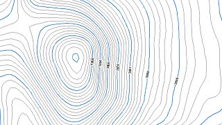
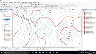
In this tutorial , I will show you how to make Raw Contours line, Smoothing Contours line using smooth line tools and how to create Index Contours line using ArcGIS software.
======================================================
🌎 GIS Work|| Best laptop at Low cost!!
Acer Predator Helios: https://amzn.to/3MzpjWM
ASUS TUF Gaming: https://amzn.to/3CwUpti
Lenovo Legion: https://amzn.to/3g87HEW
MSI Stealth: https://amzn.to/3CX9qWH
MSI GV15: https://amzn.to/3EHtSfM
Acer Nitro: https://amzn.to/3CBJLSh
======================================================
Other Useful Tutorials*****
Extract X, Y coordinates and Elevation Values (Z) of Point and Line features from DEM in ArcGIS: • Extract X, Y coordinates and Elevatio...
Topographic Ruggedness Index Calculation using DEM in ArcGIS and QGIS: • Topographic Ruggedness Index Calculat...
Applying Scale Factor to the Collection 2 Level 2 Surface Reflection Data and Calculate NDBI: • Applying Scale Factor to the Collecti...
Detail method to do Radiometric Atmospheric Correction of Landsat 8 Images using ArcGIS: • Видео
ArcGIS Geodatabase Design Basic File Geodatabase, Field, Subtype, Domain: https://cutt.ly/JYSmgQa
Free Spatial Data |Shapefile| of Any Country & Humanitarian Data: https://cutt.ly/1WawYD1
Land Cover Data 10 m Resolution: https://cutt.ly/3Waqcvo
Least Cost Path: https://cutt.ly/xWaqmEb
Download Open street Map: https://cutt.ly/SWaqWFk
Stream Power Index SPI Calculation:https://cutt.ly/jWaqT9t
Topographic Wetness Index TWI Calculation: https://cutt.ly/qWaqIw5
Suitability Analysis Using Arcgis: https://cutt.ly/6WaqSnA
Add xy data from excel, clip, select, split, table select tools in ArcGIS: https://cutt.ly/mWaqGuS
Drainage or Stream Frequency & Infiltration number: https://cutt.ly/7WaqJ5U
Calculate Stream or Drainage Density: https://cutt.ly/VWaqX36
Extracting Stream or Drainage Network from DEM: https://cutt.ly/QWaqMS9
Detail Watershed Delineation using DEM: https://cutt.ly/TWaq3Lk
ArcGIS Tutorial:https://cutt.ly/qWaq7gu
Qgis Tutorial: https://cutt.ly/ZWaq6e2
Change Detection: https://cutt.ly/sWawwfX
Download Free Shapefile:https://cutt.ly/XWawrsG
Download Soil Organic Carbon, Evapotranspiration, Land cover, Precipitation Data: https://cutt.ly/cWawtFC
Human Influence Calculation: https://cutt.ly/TWawuPv
Lineaments Extraction :https://cutt.ly/sWawi3K
World Soil Map Shapefile: https://cutt.ly/tWawaxY
Hotspot / Kernel Density Analysis: https://cutt.ly/nWawgLt
GIS Shapefile Data ( Road, Structure, etc.) for Any Country: https://cutt.ly/WWawjPq
Land Cover Change Detection: https://cutt.ly/cWawleE
Soil Moisture Index and Land Surface Temperature Calculation: https://cutt.ly/tWawzhs
Calculate normalized burn ratio (NBR): https://cutt.ly/WWawxL9
Keyword: create elevation map in arcgis,generate contours from dem in arcgis, arcgis create contours from points,make elevation map in qgis, create an isopleth map in arcgis, qgis topographic map, arcmap draw contour lines on a topographic map, how to draw contour lines in processing, arcgis contour,smooth line in arcgis,smoothing lines in arcgis,
arcgis create contours from points, gis contour lines, how to create contour lines in arcmap, how to draw contour lines using arcmap, how to draw contour lines on maps, contour, topographic map, elevation, arcgis, esri, gis, contour map using googlearth,contour map using arcgis,
topographic maps, learning,best solution line,lines, how to draw contour lines in processing,arcgis contour,arcgis create contours from points,gis contour lines,explore rs & gis tutorials
Contact if need***
Facebook: / rsgistutorial
Twitter: / rsexplore
Linkdin: / siam-khan-89236a1b9


Информация по комментариям в разработке