https://axera.org/to53/
For more information, please click here.
Ukiyoe of the Fifty-three Stages of the Tokaido drawn by Hiroshige Utagawa, I researched the view from where it was seen and actually went there. The route to the places depicted together with explanations of the history and topography of the area are also included in the book.
Click here to view the 100 Famous Places Edo.
Japanese version
https://www.axera.co.jp/edo100/index....
English version
https://www.axera.co.jp/edo100views/i...
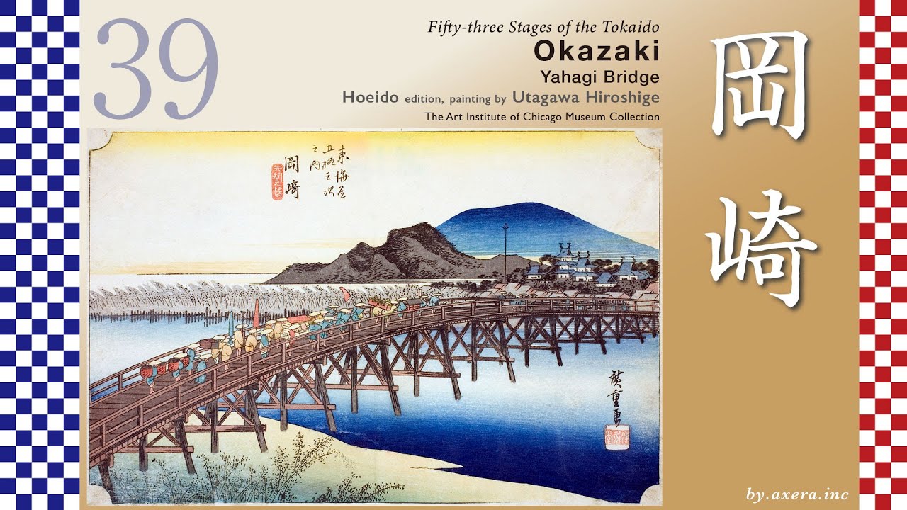
This is Yahagi Bridge, once praised as “the greatest bridge in the land.”
And beyond it rises Okazaki Castle, the birthplace of Tokugawa Ieyasu himself.
The distance from Fujikawa-juku to Okazaki-juku was one and a half ri, about six kilometers.
Leaving Fujikawa-juku, the road soon passes through the hills, heading northwest, never straying far from what is now National Route 1.
Just after crossing the Meitetsu railway, the scenery suddenly changes.
A long stretch of pine trees begins here ―
the famous Fujikawa Pine Avenue.
In its prime, the pines dominated the landscape for a remarkable distance.
Even today, remnants remain along the old road until it merges with Route 1.
During the Edo period, the Tokaido ran straight across the Otogawa River at this point.But today, the bridge is gone, and the route is forced to detour along the Route 1.
Beyond the river lies Ohira Town.Here stood the jin’ya, or administrative headquarters, of the Nishi-Ohira Domain ―built by none other than the legendary magistrate, Ooka Echizen no Kami Tadasuke.
The Tokaido then passes alongside the Okazaki Interchange, leaves Route 1, and follows a narrow eastern path.
On the right stands a stone lantern of Akiha Shrine.
From here on, you have officially entered Okazaki-juku.
Look closely at this enlarged map.
The roads around Okazaki-juku twist and turn in an almost unnatural way.
Every bend served one purpose: defending Okazaki Castle.
This maze-like layout is known as the “Twenty-Seven Turns.”
Its eastern starting point was the Kaburagi Gate ―
now replaced by a modern traffic roundabout.
The heart of the relay station lies at what is now the Denma-cho intersection.
This area once concentrated the town’s key facilities:
the Honjin, relay offices, and the Toiya.
Eventually, the Tokaido makes a wide detour around Okazaki Castle and heads toward the Yahagi River.
Here, warehouses of Hatcho miso line the street.
A short distance further north stood Yahagi Bridge.
Utagawa Hiroshige is believed to have drawn Okazaki Castle from the far side of this bridge, after crossing it.
The red gradient marks his presumed viewpoint.
Okazaki Castle was famous as the birthplace of Tokugawa Ieyasu.
For that reason, it was ruled by fudai daimyo, hereditary retainers of the Tokugawa.The Okazaki Domain itself, founded by the Honda Hikojiro family, held only 50,000 koku ― a relatively small domain.
Yet the Yahagi River was a vital artery for water transport.
Combined with the castle’s prestige, becoming lord of Okazaki was considered a true status symbol among daimyo.
Supported by the legacy of the Shogun’s birthplace, Okazaki-juku grew into one of the largest relay station on the Tokaido ―second only to Sunpu in Suruga Province.
At the time Hiroshige created this print, Okazaki Castle was ruled by the Honda Heihachiro family.
Descendants of the famed Honda Tadakatsu, they maintained a large retinue of retainers.
Managing a domain of only 50,000 koku under such conditions was, unsurprisingly, a serious financial burden.
Now, let’s examine Hiroshige’s artwork more closely.
Yahagi Bridge was the longest bridge on the entire Tokaido.
It was washed away and rebuilt many times.
At its longest, it stretched 380 meters, supported by seventy bridge pillars.
People even said,
“Mention Okazaki, and you think of Yahagi Bridge.”It was the very symbol of the highway.
According to Edo-period bridge rankings,the western champion was Kintai Bridge in Yamaguchi ―and the eastern champion was Yahagi Bridge.

Информация по комментариям в разработке