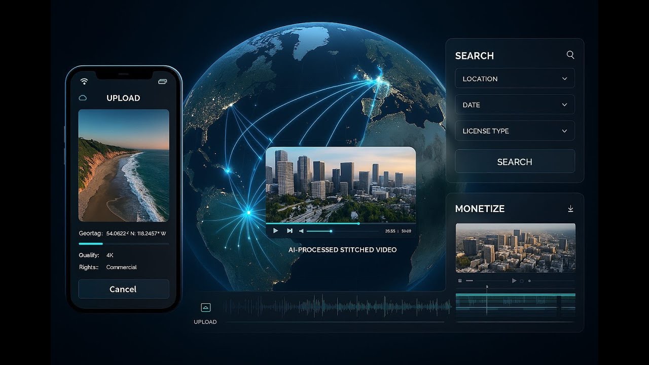
Open Aerial brings drone pilots, editors, agencies, and civic users into one pipeline. Contributors upload geo tagged footage with releases. AI scores quality, aligns and stabilizes shots, colour matches sequences, and stitches multi contributor reels. Buyers search by map and time, then license clips with clear payouts to every contributor by seconds used. This connects contribution to monetization with transparent rights and audit trails.
Vision Statement
The platform aims to create the largest, and most valuable library of geo-tagged drone footage by enabling anyone to contribute, aggregate, and monetize aerial content. Leveraging AI, the platform seamlessly stitches together drone footage from multiple contributors, making high-quality aerial media readily searchable, licensable, and usable by various stakeholders.
As usual outline: SRS Business case and other artifacts: Open Aerial artifacts note some documents are labelled as SkyShare AI (as the name is TBD) and are initial docs see : https://drive.google.com/drive/folders/10E... for full long form article see: https://ideaswiz.com/open-aerial-crowdsour...
Pain Points
· Fragmented Solutions: Current drone platforms either specialize in sharing, editing, or mapping—but not all three. Contributors lose value due to absence of a centralized, rights-managed platform.
· Lost Value: Thousands of hours of drone footage remain unused as there is no effective aggregation, rights management, or monetization system.[
· High Entry Barrier: AI stitching and professional editing are costly for individuals; a collaborative compilation process would reduce costs.
· Slow Post-Production: Editors spend substantial time on stabilizing and matching footage, while buyers seek verified, instantly licensable aerials sorted by geo/time.
· Unclear Rights and Payouts: Rights management is complex, with unclear contributor incentives and monetization routes.
· Regulatory Pressure: Compliance with evolving drone regulations, such as Remote ID requirements and airspace mapping, is increasingly essential.
Solution Features
· Contributor App: Upload capability with auto-captured metadata, batch tagging, releases, and payout setup.
· AI Ingest and Stitching Pipeline: Handles ingest, duplicate checks, scoring, alignment, stabilization, color matching, and seamless composition of reels and clips.
· Map and Timeline Search: Geo-temporal search interface for both contributors and buyers, with instant licensing and delivery.
· Rights and Monetization Dashboard: Rights-setting templates, transparent revenue share (typically 70% to contributors by seconds used), payout records, and takedown/dispute workflows
· Quality Control: AI and manual checks for GPS sanity, focus, shake, horizon, noise profile, and compliance with airspace/privacy requirements.
· Admin and Moderation Tools: Rights audit, fraud detection, compliance tracking, automated geofencing, and takedown SLAs.
· Bounty Challenges and Collaboration Spaces: Allow buyers to request footage for specific events, locations, or timeframes, and enable contributors to compete or collaborate
· APIs for Enterprise Partners: Programmatic archive querying, usage-based licensing, and vertical integration with third-party apps, editing platforms, and mapping stacks
Product & Service Description: See appendices for further details
The platform operates as a media pipeline from upload to payout, integrating community contribution, advanced AI stitching, licensing, and transparent revenue management:
· Contributors: Upload geo-tagged footage, auto-extract metadata, tag in batches, set rights, and receive transparent payouts.[2][3]
· Buyers and users: Search by map, date/time, and scenario; instantly license stitched sequences or atomized clips (editorial, commercial, broadcast, enterprise tiers). Teirs: free, paid and subscription model tbd
· Revenue Model: 30% platform take, 70% contributor split by seconds used; tiered licensing and subscriptions for both pro contributors and buyers; enterprise APIs for bulk access and delivery.
· Compliance Model: Automated checks for no-fly zones, regulatory and privacy compliance, metadata validation, GDPR adherence, and dynamic geofencing.

Информация по комментариям в разработке