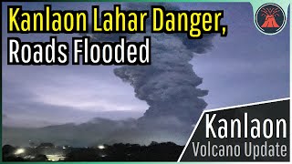
For the 2nd time in 6.5 months, a lethal disaster sadly occurred at the erupting Mount Marapi volcano. This occurred due to heavy rainfall, which washed quickly away downslope to the prior incineration of a patch of ground due to Marapi's December 3rd eruption. As a result, a lahar with an estimated height of 30 feet was generated which damaged dozens of structures. This video explains why this lahar was generated, and the danger that so-called "secondary lahars" can generate.
Thumbnail Photo Credit: Cropped image taken from Explore West Sumatra's video, • GUNUNG MARAPI SUMATRA BARAT: DRONE NY... . Used with Permission.
Please subscribe to Explore West Sumatra, who granted me permission to use their drone footage in this video!
Channel link: / @explorewestsumatra
Source footage video links:
[1] • GUNUNG MARAPI SUMATRA BARAT: DRONE NY...
[2] • BANJIR BANDANG (GALODO) DAN LONGSOR D...
If you would like to support this channel, consider using one of the following links:
(Patreon: / geologyhub )
(YouTube membership: / @geologyhub )
(Gemstone & Mineral Etsy store: http://prospectingarizona.etsy.com)
(GeologyHub Merch Etsy store: http://geologyhub.etsy.com)
Google Earth imagery used in this video: ©Google & Data Providers
This video is protected under "fair use". If you see an image and/or video which is your own in this video, and/or think my discussion of a scientific paper (and/or discussion/mentioning of the data/information within a scientific paper) does not fall under the fair use doctrine, and wish for it to be censored or removed, contact me by email at [email protected] and I will make the necessary changes.
Various licenses used in sections of this video (not the entire video, this video as a whole does not completely fall under one of these licenses) and/or in this video's thumbnail image (and this list does not include every license used in this video and/or thumbnail image):
Public Domain: https://creativecommons.org/publicdom...
CC BY 4.0: https://creativecommons.org/licenses/...
Sources/Citations:
[1] PVMBG
[2] Brown, S.K., Jenkins, S.F., Sparks, R.S.J. et al. Volcanic fatalities database: analysis of volcanic threat with distance and victim classification. J Appl. Volcanol. 6, 15 (2017). https://doi.org/10.1186/s13617-017-00..., CC BY 4.0.
[3] VEIs, dates/years, composition, tephra layer name, DRE estimates, and bulk tephra volume estimates for volcanic eruptions shown in this video which were assigned a VEI 4 or larger are sourced from the LaMEVE database (British Geological Survey © UKRI), https://www2.bgs.ac.uk/vogripa/view/c..., Used with Permission
[4] Source of Volcanic Explosivity Index (VEI) methodology and criteria: Newhall, C. G., and Self, S. (1982), The volcanic explosivity index (VEI) an estimate of explosive magnitude for historical volcanism, J. Geophys. Res., 87(C2), 1231–1238, doi:10.1029/JC087iC02p01231. Accessed / Read by / geologyhub on Oct 5th, 2022.
0:00 A Destructive Lahar
0:47 Heavy Rainfall
3:23 Eruption Size
4:03 Secondary Lahars


![Что происходит в «крытом океане»? [Veritasium]](https://i.ytimg.com/vi/rPLsrsZNGVQ/mqdefault.jpg)


Информация по комментариям в разработке