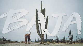
Baja California ('Lower California'), officially the Free and Sovereign State of Baja California is a state in Mexico. It is the northernmost and westernmost of the 32 federal entities of Mexico. Before becoming a state in 1952, the area was known as the North Territory of Baja California. It has an area of 70,113 km2 (27,071 sq mi) (3.57% of the land mass of Mexico) and comprises the northern half of the Baja California Peninsula, north of the 28th parallel, plus oceanic Guadalupe Island. The mainland portion of the state is bordered on the west by the Pacific Ocean; on the east by Sonora, the U.S. state of Arizona, and the Gulf of California; on the north by the U.S. state of California; and on the south by Baja California Sur.
The state has an estimated population of 3,769,020 (2020), significantly higher than the sparsely populated Baja California Sur to the south, and similar to San Diego County, California, to its north. Over 75% of the population lives in the capital city, Mexicali; in Ensenada; or in Tijuana. Other important cities include San Felipe, Rosarito and Tecate. The population of the state is composed of Mestizos, mostly migrants from other parts of Mexico, and, as with most northern Mexican states, a large population of Mexicans of Spanish ancestry, and also a large minority group of East Asian, Middle Eastern and indigenous descent. Additionally, there is a large immigrant population from the United States due to its proximity to San Diego and the lower cost of living compared to San Diego. There is also a significant population from Central America. Many immigrants moved to Baja California for a better quality of life and the number of higher-paying jobs in comparison to the rest of Mexico and Latin America.
Baja California is the twelfth largest state by area in Mexico. Its geography ranges from beaches to forests and deserts. The backbone of the state is the Sierra de Baja California, where Picacho del Diablo, the highest point of the peninsula, is located. This mountain range effectively divides the weather patterns in the state. In the northwest, the weather is semi-dry and Mediterranean. In the narrow center, the weather changes to be more humid due to altitude. It is in this area where a few valleys can be found, such as the Valle de Guadalupe, the major wine-producing area in Mexico. To the east of the mountain range, the Sonoran Desert dominates the landscape. In the south, the weather becomes drier and gives way to the Vizcaíno Desert. The state is also home to numerous islands off both of its shores. In fact, the westernmost point in Mexico, Guadalupe Island, is part of Baja California. The Coronado Islands, Todos Santos islands and Cedros Island are also on the Pacific shore. On the Gulf of California, the biggest island is Angel de la Guarda Island, separated from the peninsula by the deep and narrow Canal de Ballenas.
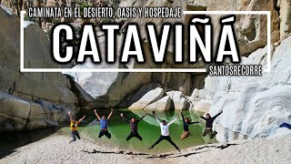
Cataviña is a small town on Federal Highway 1 in the Mexican state of Baja California. It is located 118 km (74 mi) south of El Rosario and 106 km (66 mi) north of the junction of Federal Highway 12 to Bahía de los Ángeles.
The local economy is dependent on tourism, ranching (Rancho Santa Inés, on the outskirts of the town, is an ejido held in common by the residents), and a couple of private vendors selling gasoline from 55 gallon barrels. Those planning a trip that includes Cataviña, need to make sure to purchase enough fuel to get from El Rosario to Villa Jesús María, to avoid the necessity of buying the private vendor gasoline just mentioned (the Pemex station in Cataviña is closed, permanently.)
Cataviña has a first-rate hotel developed by the National Fund for the Promotion of Tourism in the Mexican government. Nearby are some cave paintings and a field of giant rocks, mixed with desert vegetation, which make the area a place visited for lovers of ecotourism.
You can see other Tijuana videos:
Tijuana, Mexico 4K - • Tijuana, Mexico | Baja California | D...
Zona Norte, Tijuana 4K - • Zona Norte, Tijuana | Red Light Distr...
Driving Around Zona Rio, Tijuana 4K - • Driving Around Tijuana [4K] | Zona Ri...
Aerial View Of Tijuana Dam 4K - • Видео
Driving In Tijuana At Night 4K - • Driving In Tijuana At Night [4K] | Ba...
Tijuana Zona Centro 4K - • Tijuana Zona Centro [4K] | Baja Calif...
Driving Around Playas De Tijuana 4K - • Driving Around Playas De Tijuana [4K]...
Agua Caliente Blvd Tijuana 4K - • Tijuana [4K] Agua Caliente Blvd | Mexico
Don't forget to LIKE 👍 this video, SUBSCRIBE ❤️ to my channel so you will not miss other great videos that are coming soon! Also, LEAVE A COMMENT 📝 about what you think about this video and what you would like to see next...
#bajacalifornia #baja #roadtrip #mexico

![[Full] CALIFORNIA STATE ROUTE 1 - Driving Pismo Beach to Big Sur and Carmel, California, USA, 4K](https://i.ytimg.com/vi/qZI2j3AFsYQ/mqdefault.jpg)


![Tijuana, Mexico | Baja California | Driving Downtown [4K]](https://i.ytimg.com/vi/0haPpZU7CMI/mqdefault.jpg)


Информация по комментариям в разработке