This Video is 4K UHD - it is made to watch on a Big Screen Smart TV!
Nearby Campgrounds in Metolius River National Recreation Area.....
Lower Bridge Campground - • (4K UHD) REVIEWING EACH CAMPSITE @ Lower B...
Candle Creek Campground - • (4K UHD) REVIEWING EACH CAMPSITE @ Candle ...
Pioneer Ford Campground - • (4K UHD) REVIEWING EACH CAMPSITE @ Pioneer...
Allen Springs Campground - • (4K UHD) REVIEWING EACH CAMPSITE @ Allen S...
Gorge Campground - • (4K UHD) REVIEWING EACH CAMPSITE @ Gorge C...
Pine Rest Campground - • (4K UHD) REVIEWING EACH CAMPSITE @ Pine Re...
Smiling River Campground - • (4K UHD) REVIEWING EACH CAMPSITE @ Smiling...
Allingham Campground - • (4K UHD) REVIEWING EACH CAMPSITE @ Allingh...
Lower Canyon Creek Campground - • (4K UHD) REVIEWING EACH CAMPSITE @ Lower C...
Monty Campground - • REVIEWING EACH CAMPSITE @ Monty Campground...
Perry South Campground - • REVIEWING EACH CAMPSITE @ Perry South Camp...
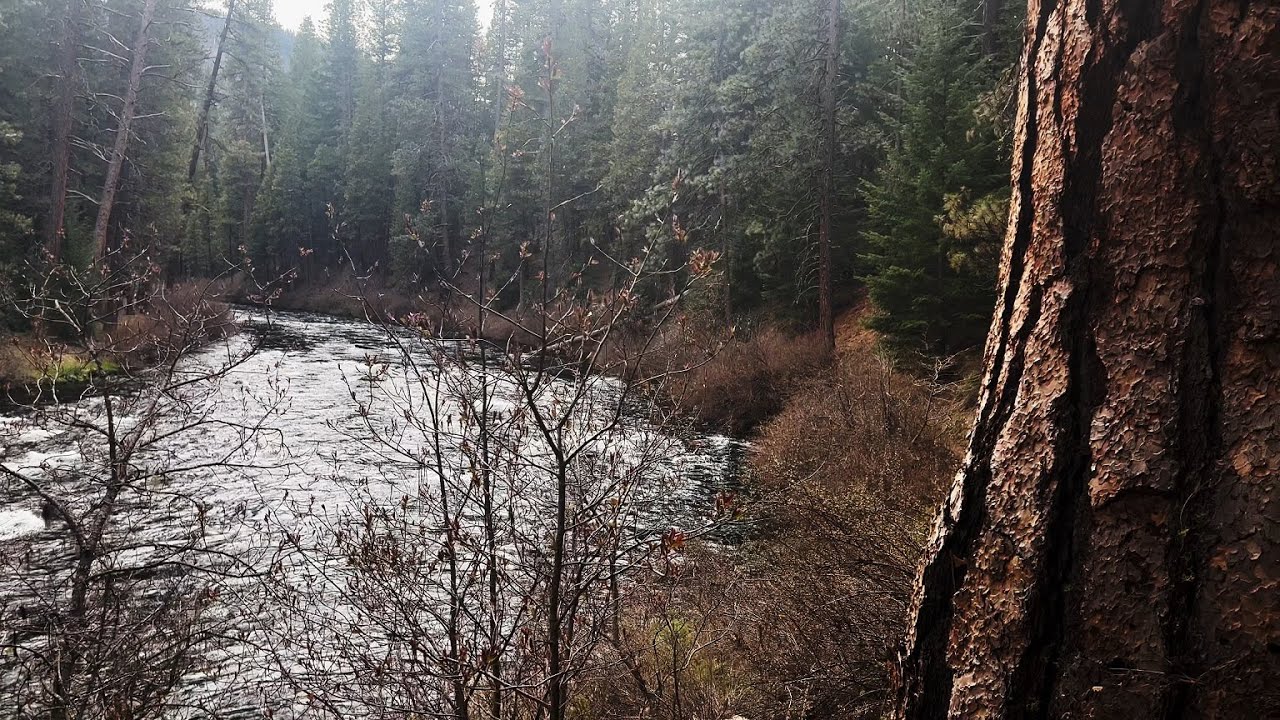
This was a Day Hike in Central Oregon, Metolius River National Recreation Area, Deschutes National Forest, starting @ Lower Bridge Campground Parking at Lower Bridge and crossing the Bridge to the Trailhead for West Metolius River Trail to Candle Creek Campground as an Out & Back with miles of EPIC shoreline Hiking and a very minor amount of Elevation Gain making it mostly a flat Hike. The elevation starts around 2800 FT and stays in a range of up to 3000 FT, at such low elevation it allows this Hike to be done in the end of Winter (late Feb and forward) as far as snow melt and road access. The sky was overcast and it sprinkled a little bit. This was Hiked on 4/28/2022, and there were of course NO Mosquitoes.
Lower Bridge Campground, Deschutes National Forest, Central Oregon, is nestled in a towering Ponderosa Pine Forest situated on the Shoreline National Wild & Scenic Metolius River! In my opinion, it is easily a Top Tier Campground in the entire Metolius River National Recreation Area, an area with 15 Developed Campgrounds! Metolius River is arguably the TOP FLY FISHING DESTINATION in the State of Oregon! Also worth noting, Lower Bridge Campground (along with Allen Springs Campground, Pine Rest Campground & Camp Sherman Campground) is one of 4 Campgrounds that is Open Year Round! During "Prime Time" Summer it is Reservable @ Recreation.gov, but the rest of the year it is First Come, First Served. At only 2700 FT Elevation, this is an ABSOLUTELY AMAZING Shoulder Season Camping Play! Last thing worth noting - it's namesake is the Bridge over to Candle Creek Campground.
My recommendations for the Best Campsites:
#10, #9, #8, #6
Candle Creek Campground is one of only two Campground on the WEST SIDE of Metolius River in the world famous Metolius River National Recreation Area and is in fact THE LAST ONE, the end of the line of this River Forest Wonderland Zone up against the edge of Deschutes National Forest! After crossing the Bridge @ Lower Bridge Campground it has a long and windy Forest Road to get to it - it is a little washboard bumpy in a few sections but overall is very doable for any vehicle in my humble opinion, of course do so at your own risk! What makes Candle Creek Campground so special in edition to its privacy and being at the edge of the area, is that it is situated at the confluence of Metolius River & Candle Creek, the namesake for the Campground! Thus there is no bad Campsite at Candle Creek - when you arrive, the Campsites on the right are up against/above Metolius River, and the Campsites on the left are up against/above Candle Creek! These two flowing bodies of water meet up in the backyard area of Campsite #6, which has a side path down to a small flat area you could put your chairs to sit at this truly incredible confluence - babbling creek to your left and raging white water rapids to your right! Thus it is my opinion that Campsite #6 is the BEST Campsite at Candle Creek Campground, and is arguably THE BEST CAMPSITE in the entire 15 Campground Metolius River National Recreation Area!
My recommendations for the Best Campsites:
#6, #5, #4, #3
Both of these Campgrounds can be used as a launching off point to Hike/Explore the entire Metolius River National Recreation Area! If you wanted to do The Whole Enchilada capturing both sides of Metolius River i.e. West Metolius River Trail AND East Metolius River Trail, you can do so in one approximately 13.5 Mile Grand River Shoreline Hike that CAPTURES ALL THE HIGHLIGHTS of the Area! I would recommend referencing AllTrails and Google Maps to create your Grand Loop Hiking Itinerary! The Area is relatively Low Elevation, in the 2800 FT - 3000 FT Range, and there is not much Elevation Gain in this 13.5 Mile Hike beyond the natural machinations of a Forest Hike/Trail. This Hike can typically be done from Late Winter (depending on annual snow melt) to Spring to Summer to Fall (until the annual snow deluge starts), so it has an unusually long window to Hike due to its Low Elevation and is a GREAT Shoulder Season Play to avoid the Hot Summer Heat!

Информация по комментариям в разработке