📍地點|高雄市桃源區・瓦筏哈橋(台20線南橫公路)
📅拍攝狀態|完工通車後・空拍紀錄
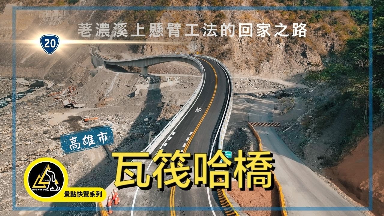
本影片以空拍視角,紀錄 瓦筏哈橋正式完工並開放通車後的整體景觀。
鏡頭自高空俯瞰橋梁橫跨河谷的壯闊尺度,呈現橋體線條、橋面延伸方向,以及周圍山巒、溪流與道路之間的空間關係。
瓦筏哈橋位於南橫公路關鍵節點,橋梁完工後,視覺上不僅是一條交通設施,更成為山區地形中一條清晰而穩定的連結線。
透過空拍畫面,可以清楚感受橋面高度、跨距設計,以及它在廣闊河床與群山包圍下所形成的對比與平衡。
本片不包含施工或工程紀錄,專注於 「通車後的樣貌」,以純粹影像方式,保留此一時間點的風景狀態,作為南橫公路重建階段中的一段視覺紀錄。
🎥 拍攝形式|無人機空拍(DJI Mavic 3 Pro)
🛣 主題重點|橋梁景觀・河谷地形・道路與自然共構
⚠️ 影片僅作影像紀錄與風景呈現,非工程或交通資訊說明
📍Location|Taoyuan District, Kaohsiung, Taiwan – Uavaha Bridge (Provincial Highway T20)
📅Filming Stage|After completion and official opening
This aerial video documents the Uavaha Bridge after its completion and opening to traffic, captured entirely from a drone perspective.
The footage presents a wide, unobstructed view of the bridge spanning the river valley, highlighting its structure, alignment, and scale in relation to the surrounding mountains, riverbeds, and roadway network.
From above, the bridge appears not only as infrastructure, but as a clear and steady line connecting terrain, movement, and landscape.
Rather than focusing on construction or engineering processes, this video concentrates solely on the completed bridge in its operational state, preserving the visual character of this moment along the Southern Cross-Island Highway.
Through aerial imagery, viewers can observe the bridge’s height, span, and spatial presence within the vast natural environment—an intersection of human design and rugged geography.
🎥 Filming Method|Drone aerial footage(DJI Mavic 3 Pro)
🛣 Focus|Bridge landscape, river valley, road and terrain composition
⚠️ This video is a visual and scenic record only, not an engineering or traffic report
📌 橋梁背景說明 瓦筏哈橋(Uavaha) 取自布農語,意指「公鹿棲息之處」,含有在地文化象徵意義。 該橋位於 台20線南橫公路 勤和至復興路段,是連結桃源區與外界的重要通道,原先位於此段的「明霸克露橋」多次遭洪水與土石流沖毀,尤其 2021年「盧碧颱風」與2024年「凱米颱風」造成橋梁重大損毀,長期影響當地交通與生活。 新橋採 3跨連續梁設計,加大跨距並提高橋面垂直高度,以強化抗洪與耐災能力。 整體工程歷時 約2年多、耗資近5億元,融合工程與防災考量,是南橫重建的重要里程碑。 對當地 勤和、復興、拉芙蘭與梅山等部落而言,瓦筏哈橋意謂「不再孤立」的安全回家路。
📌 Bridge Background
The Uavaha Bridge derives its name from the Bunun language, meaning “the place where deer inhabit,” and carries significant cultural symbolism rooted in the local indigenous heritage.
The bridge is located on Provincial Highway T20 (Southern Cross-Island Highway) between the Qinhe and Fuxing sections, serving as a critical transportation link connecting Taoyuan District with the outside regions.
The former bridge at this location, Mingbake Bridge, was repeatedly damaged by flooding and landslides. In particular, Typhoon Lupit in 2021 and Typhoon Gaemi in 2024 caused severe structural destruction, resulting in prolonged disruptions to local transportation and daily life.
The newly constructed bridge adopts a three-span continuous girder design, featuring an increased span length and a higher deck elevation to enhance flood resistance and disaster resilience.
The project required over two years to complete and an investment of nearly NT$500 million, integrating advanced engineering solutions with disaster-prevention considerations. It stands as a major milestone in the reconstruction of the Southern Cross-Island Highway.
For the nearby communities of Qinhe, Fuxing, Lafulan, and Meishan, the Uavaha Bridge represents a safe and reliable route home—symbolizing an end to isolation and a restoration of secure connectivity.

Информация по комментариям в разработке