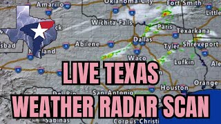
The final week of May is upon us, and like every week since late April, we’ll have multiple chances for thunderstorms. After a deadly tornado outbreak on Saturday, it is understandable that many will feel heightened anxiety or be hyper-sensitive to thunderstorm forecasts. The tornadic supercell that produced multiple strong to intense tornadoes in North Texas late Saturday is rare – even in a state that experiences many severe storms and tornadoes annually. These forecast discussions are not meant to frighten but to inform. Your attention to the weather is crucial and already puts you in a better position than most. Even on days when we’re not confident about what may happen, we try to provide you with the most likely scenarios – while explaining a few alternatives that could ‘make or break’ the forecast.
Today, the most likely scenario is isolated afternoon thunderstorms across the eastern half of Texas, northwest into the Texas Panhandle. As we endure another summer-like day, the cap (lid) on the atmosphere will weaken, and a few storms may develop. Large hail and localized damaging winds would likely be associated with any storms that did manage to develop. The chance for some storms in North Texas and Northeast Texas will continue into late tonight with the same risks.
A lower probability scenario, but one we need to monitor, is that a supercell thunderstorm (one, maybe a few) manages to develop near a boundary located in North Texas and Central Texas. Low-level wind shear will be weak today, keeping the tornado threat very low. However, with extreme instability in place, any storm near a boundary – or remaining very intense into the evening hours – may have a higher threat of a tornado. Nine out of ten times, these events come and go without much hoopla. However, this is one of those low probability – high impact scenarios. We want to assure you that we’ll keep close tabs on it, and if it becomes a more likely scenario, we’ll update our forecast accordingly this afternoon. Again, I realize many are hyper-sensitive after Saturday, but most Texans won’t see a storm today – nevertheless, one going holy moly guacamole.
Thunderstorm chances will increase on Tuesday across several regions of Texas. A cluster of storms may develop tonight into Tuesday morning in Oklahoma. If that happens, we may see it move southeast into Texoma, North Texas, and the Ark-La-Tex tomorrow morning or early afternoon. Locally heavy rain, gusty winds, and some hail would be possible with the stronger storms.
Isolated to scattered severe storms are expected to develop Tuesday afternoon east of a dryline in West Texas south into the Permian Basin. The initial storms will likely produce very large hail, localized damaging winds, and perhaps a tornado. With time and by Tuesday evening, those storms will grow into a large cluster or line that begins accelerating east/southeast toward the Big Country, Concho Valley, and eventually make it into the Hill Country late Tuesday or early Wednesday. There are indications that this thunderstorm cluster could become quite strong with damaging to localized hurricane-force wind gusts – a longer-lived line of severe storms.
Rain chances will continue off and on through the remainder of the work week across Texas. I’m happy to say we’ll see those rain chances also continue across western portions of Texas – where they really could use the rain. As usual, it’s either feast or famine – and we may end up having too much of a good thing in parts of Texas this week with several inches of rain possible.
Join this channel to get access to perks:
/ @texasweathercenter
Check out our current LIVE STREAM: https://texasweather.video/
Our FREE WEATHER APP: https://texasweather.app/
Our WEBSITE/RADAR: https://www.texasstormchasers.com
Our SOCIAL PLATFORMS: https://linktr.ee/texasstormchasers
Donations - [email protected]
Enable 4K 60FPS when possible for best viewing results
#texas #texasweather #weather #abilene #alpine #amarillo #austin #beaumont #beeville #bigbend #brownsville #brownwood #canadian #childress #collegestation #coriscana #corpuschristi #crashythecoldfront #dalhart #dallas #davidreimer #delrio #denton #derecho #dfw #dfwmetroplex #dumas #eaglepass #elcampo #elpaso #flashflood #flood #fortstockton #fortworth #galveston #georgetown #gorillahail #granbury #hail #hereford #houston #hurricane #idabel #killeen #longview #lubbock #lufkin #marfa #mcallen #midland #news #odessa #pampa #paristx #perryton #plainview #rain #rgv #roundrock #sanangelo #sanantonio #severe #sherman #shreveport #storm #stormchasers #storms #stormsurge #supercell #temple #texarkana #texas #texasfire #texasflood #texasstormchasers #texasweather #TexasWildfire #texoma #today #todaynews #todaysweather #tornado #txwx #tyler #uvalde #vernon #victoriatx #waco #Weather #weatherforecast #wichitafalls #wildfire #wind #windy #winter


Информация по комментариям в разработке