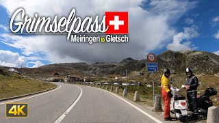
Driving from Gletsch to Innertkirchen (Swiss road Nr 6 - Grimselstrasse) through Grimselpass (elevation 2164m ~ 7100 feet).
Timestamps: 0:00 Gletsch, 04:10 view on Furka pass road, 06:20 Grimselpass & Totesee, 07:30 Hotel Grimsel Passhöhe & Sankt Christopherus chapel, 11:10 Grimselsee, 15:49 Räterichsbodensee (+ dam), 22:40 Handeck/Handegg, 29:00 Guttannen, 32:50 Boden, 38:30 Innertkirchen.
To play this video faster - click settings - and choose 1.25, 1.5, 1.75 or 2 times faster.
WIKI
The Grimsel Pass (German: Grimselpass; French: Col du Grimsel; Italian: Passo del Grimsel) is a mountain pass in Switzerland, crossing the Bernese Alps at an elevation of 2,164 metres (7,100 ft). The pass connects the Haslital, the upper valley of the river Aare, with the upper valley of the Rhône. In so doing, and as the Aare is a tributary of the Rhine, the pass crosses the continental divide between the North Sea and the Mediterranean Sea.
A paved road follows the pass, running 38 kilometres (24 mi) from Gletsch to Meiringen.
The Grimsel Pass road is part of the Aare Route, which is national cycle route 8 of Switzerland. It has been used on several occasions by the Tour de Suisse.
The Grimsel Pass connects the cantons of Bern, to the north, and Valais, to the south, with the summit of the pass lying on the cantonal boundary. The northern slopes of the pass are in the Bernese municipality of Guttannen, whilst the southern slopes are within the Valais municipality of Obergoms.
At the summit are several hotels and an extensive area of parking. Here the road runs alongside the Totesee (2,160 metres or 7,090 feet), a natural lake that has been enlarged into a reservoir. To the west of the pass and lake is the peak of the Sidelhorn (2,764 metres or 9,068 feet), whilst to the east is the mountain range Schafberg (2,481 metres or 8,140 feet).
Weather
The road is normally closed between October and May, due to the high snowfall on the pass. As it is the only direct road pass between the cantons of Bern and Valais across the Bernese Alps, attempts are made to keep the road open as long as possible with snow ploughs. A PostBus Switzerland service uses the pass several times a day, connecting Meiringen and Oberwald.
Climate
Due to the high altitude of the pass, and its continental location, the climate is cool or cold all year round, and receives a fair amount of precipitation year-round (the majority of which is snow). Snow usually falls from late September until late June, although during cool spells, it can snow at the height of summer. Most years, permanent snow fields remain at the pass, due to the temperature rarely rising above 15 °C. This area has a long winter season, with little precipitation mostly in the form of snow, and low humidity. The Köppen climate classification classifies the climate here as subarctic.
Grimselsee
The Grimselsee or Lake Grimsel is an artificial lake near the Grimsel Pass in the Canton of Berne, Switzerland. With a volume of 95 mio m³, it is larger than other hydroelectric reservoirs in the region: Oberaarsee, Räterichsbodensee and Gelmersee. The dam was completed in 1932 and is operated by Kraftwerke Oberhasli AG (KWO). It is located in the municipality of Guttannen.
GEO
Elevation 2,164 m (7,100 ft)
Location Bern/Valais, Switzerland
Range Alps
Coordinates 46°33.72′N 08°20.34′E


![★ 4K 🇨🇭Davos Platz - Klosters Platz - Landquart cab ride Switzerland [05.2021]](https://i.ytimg.com/vi/hGnErDPodBQ/mqdefault.jpg)
Информация по комментариям в разработке