Catoctin Creek at 2.5ft. (moderate flow)
Contents - Maps & Hydrographs (0:11), Slideshow (0:59), Video (3:45)
Date: May 9, 2020
Locations: Jefferson, Maryland
Catoctin Creek Park & Nature Center:
Sumantown Road Bridge (3:45)
Pebble Beach (4:34)
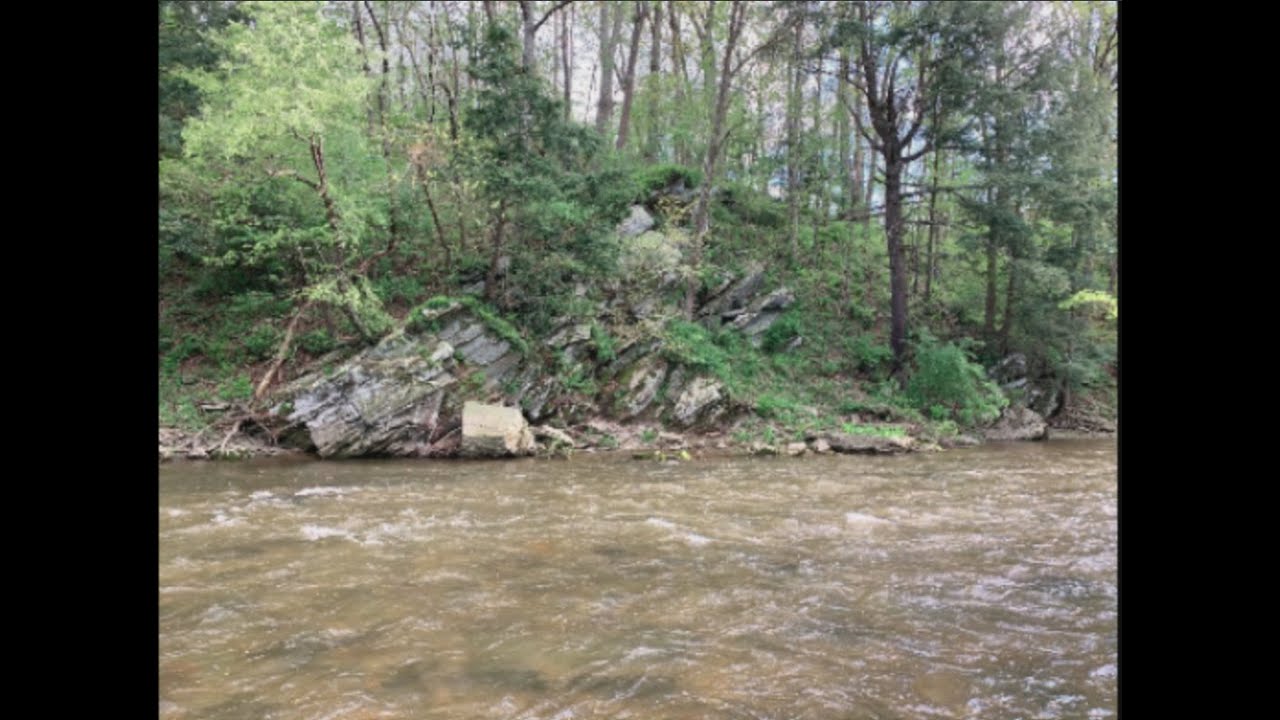
Mink Hollow (6:15)
Overlook (8:14)
Cut Bank/Meander (8:17)
Poffenberger Road (8:53)
USGS Gauge: 01637500 Catoctin Creek Near Middletown, MD
2.5ft. is where the fun starts when looking for the start of a continuous ride by kayak or canoe. Catoctin Creek tends to average a baseflow of 2.0ft. throughout the year, and sometimes hold an average of 1.9.ft during significant dry spells of the summer months. American Whitewater recommends a minimum runnable flow rate of 2.2ft.; I have ran it down to 2.0ft. in the twelve foot long Dagger Axis 12.0. 2.0ft. may have been easier to navigate in a playboat, but I can attest that the amount of scraping at 2.0ft. will diminish some of the enjoyment of the trip, unless, however, it is someone who is new to kayaking and looking to get the feel for the area at a much slower pace. I have to agree with John Duke's comment on American Whitewater, where he states that AW's recommendation of 2.2 is passable, but with 2.4ft. being more realistic as the minimum runnable flow, which I can attest to. 2.2 for me make for quite a bit of scraping in the Mink Hollow area, and long stretches of flat water. 2.4ft. is the minimum that I also recommend, and is the level that I saw two canoeists at too. For canoes, I recommend a minimum of either 2.4ft. or 2.5ft., and for the intrepid rafter who is looking for an ultra rare and wild Savage River kind of ride, I recommend a minimum of 4.5ft. (an in person estimation, but not from personal experience). My other videos provide descriptive detail of flow rates (stage) ranging from 3.0ft. to 5.3ft.) and approximate timeframes for the holding and drainage windows for multiple levels.
This video pairs with the video "Catoctin Creek at 4.7ft. (maps, video, & slideshow)" from April 30, 2020. The 2.5ft. level is at the downward end of the flow range from the major rain event of April 29th, with a slight spike of a boost of additional rainfall from May 8th. The hydrographs from both videos show the timeframe of the rise and fall for each of the one foot intervals, which provides a moderately reliable parameter for how long to expect the flow to hold at each foot, which as indicated can be as short as one hour for the five foot range and several hours when at three feet. Although the holding time is subject to variability based on the intensity and duration of the precipitation event. Hopefully the data from the hydrographs from both this and the 4.7ft. video serve as reliable model of how much time one has to catch a glimpse or a ride at one's desired level.
The northern end of Catoctin and all of Middle Creek will drop more quickly as that area has a much greater relief than the lower and southern portion of the Middletown Valley. Levels hold the longest and decrease the slowest the closer you are to the Potomac River - think of the Potomac River as sea level, which is due equally to the Catoctin's increased volume and the local geology of the southern portion of the Blue Ridge Province/Catoctin Creek Gorge. Above two and half feet should be an easy catch for close to a day, even if peak flow occurred several hours before dawn. This video serves as a comparison to demonstrate the changes in the both the volume and rate of flow and its impression on the shoreline and the surrounding environment at 4.7ft. and 2.5ft. On April 30th, the flow rate peaked at 5.04ft. (and dropped to 4.7ft. in less than an hour by the time that I had arrived). Notice the change in the log jam at Mink Hollow.
Following the terminus of Middle Creek, Catoctin Creek is 27.9 miles long and flows into the Potomac River, close to mile marker 52 along the Chesapeake & Ohio Canal, where one can see the fascinating Catoctin Creek Aqueduct. The water here comes from as far north as the Catoctin Mountain (Catoctin Mountain Park and Cunningham Falls State Park), which is the easternmost mountain of the Blue Ridge Mountains, which is part of the Appalachian Mountains Range.
The Catoctin Creek Watershed encompasses the southwestern portion of Frederick County and is situated in the Middletown Valley, with Catoctin Mountain to its east and South Mountain to its west creating its border and drainage basin. The watershed drains an area of 120 square miles, and is within the Blue Ridge Province (the Lower Middletown Valley District & the Catoctin Creek Gorge Area - with a relief of 480ft). From the bridge it is 10.94 miles to the Potomac River.
American Whitewater.org: Catoctin Creek - https://www.americanwhitewater.org/co...
USGS Stream Gauge Information - https://waterdata.usgs.gov/md/nwis/uv...
USGS Water Watch Flood Tracking Chart - https://waterwatch.usgs.gov/index.php...

Информация по комментариям в разработке