Episode three of our series features Hexagon | NovAtel Technical Marketing Specialist Paul Verlaine Gakne explaining how satellite signals are received and processed to output a position.
We illustrate the components of a satellite’s signal, how it’s received by antennas, and what happens when the signal is processed by receivers. But if you’re ready for a deeper look at GNSS concepts, you can download our Introduction to GNSS book: https://novatel.com/support/knowledge...
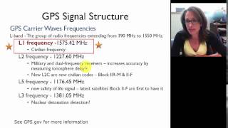
GNSS refers to global navigation satellite systems, which includes four main groups of satellites known as constellations: GPS, GLONASS, Galileo, and BEIDOU. Each constellation is managed by a different country, and they each have their own idiosyncrasies. To transmit information, satellites use radio frequencies to send satellite system data, timing, status and other information needed for accurate ranging. The satellite combines and modulates this data onto the carrier wave sent to Earth.
A GPS signal is made up of a unique identification code, known as the PRN code, used to range from a satellite to the receiver and a Navigation Message that contains satellite health, status, time and orbital information. The PRN code and navigation information are combined, and then modulates that onto the carrier wave. What results is a modulated signal that gets sent down to the receiver. Knowing how the data is superimposed onto the carrier signal, the receiver can extract the required information to range to a satellite from the modulated signal.
From a satellite, signals pass through the atmosphere towards the antenna, which senses, receives, and amplifies the satellite signal. Signals can be faint after travelling from space to Earth, so choosing the correct antenna for your application is important. Having an antenna that can receive multiple signals from multiple constellations increases the accuracy and reliability of your positioning – more access to satellites means you have more data to inform your equipment.
Once the antenna has received, amplified, and converted the radio frequency signal from a satellite, the signal is processed by receivers to de-modulate, unpack and separate the data provided. Then, the receiver outputs positioning as latitude, longitude, and height data.
Through complex equations, the receiver resolves for positioning errors and atmospheric delays, and calculates a position or more specifically geographic coordinates. With additional algorithms, receivers can also gather supplemental navigational data from other sensors.
Up to now, we’ve described the calculations underlying GNSS as determining the distance between a satellite and a receiver. We know our position is somewhere in the range of this satellite, and by multiplying the signal’s travel time by the speed of light, we can measure an estimated distance from our receiver to the satellite. This simplified equation solves for what we call a “pseudorange” -- this distance is estimated because there could be errors in the position from atmospheric delays and other factors. This equation is straightforward, but only gives meter-level accuracy.
The carrier phase calculation is a bit more complicated. Instead of solving distance based on the signal’s travel time, we’re solving for the number of wave cycles that occurred. A cycle is counted from one tip of a wave to the next. Remember that we know the frequency of the carrier signal so using that we can calculate the wavelength. By multiplying the carrier wavelength by the number of cycles that have occurred, we can compute a more accurate distance than when calculating only the pseudorange.
However, while we can now calculate positioning to a centimeter-level, counting the exact number of wave cycles between the satellite and the receiver is difficult. That means we need to verify this measurement with an additional computation. This process is called Ambiguity Resolution.
Both equations are used across GNSS applications because they are useful in different ways. While pseudorange measurements are less precise, they do not have a carrier phase ambiguity. This is what we mean when we say pseudorange measurements are accurate but not precise. Conversely, carrier phase measurements are highly precise, but typically need additional infrastructure to resolve ambiguities. For this reason, the carrier phase is often used to calculate positioning in a specific region or area, like a farmer’s field.
Our next episode will describe the ways in which common errors are resolved through equipment, algorithms, and other technologies. But, if you’re ready to get a head start in learning GNSS concepts, you can download our book An Introduction to GNSS at novatel.com


Информация по комментариям в разработке