El Bastardo Peak | La Madre Mountains Wilderness, Nevada | Visit https://lasvegasareatrails.com/el-bas... | El Bastardo is a little-known, beautiful wilderness peak on the La Madre Mountains Ridgeline West of Las Vegas, Nevada. As you stand in the familiar Red Rock Canyon, looking to the towering cliffs which form a backdrop at the upper end of the canyon, you’re looking at the La Madre Mountains Ridgeline. This ridgeline is part of the La Madre Mountains Wilderness, an area four times the size of Red Rock Canyon.
Now, notice a few of the highest points from the right side of the ridgeline (East end) to the left side of the ridgeline (West end). There’s La Madre Mountain (elevation 8,154ft) and El Padre Mountain (elevation 8,093ft), technically at the upper end of the Brownstone Basin just East of Red Rock Canyon. El Bastardo Peak (elevation 7,986ft) is actually the high point on the La Madre Ridgeline directly above the upper end of Red Rock Canyon. Between El Bastardo Peak and El Padre Mountain there is a smaller peak, easily missed: Burnt Peak (elevation 7,900ft).
The Spanish names of the peaks are interesting:
La Madre – The Mother
El Padre – The Father
El Bastardo – The Bastard
The reason the La Madre Mountains Ridgeline and its high peaks are so little known, is the difficulty in getting to them. If you’re wanting to visit the peaks from Red Rock Canyon, below to the South, you’re looking at some difficult climbing. If you’re wanting to visit the peaks from Kyle Canyon to the North, you’re looking at a less vertical but much longer approach on foot from Kyle Canyon Road (my approach), which can be substantially shortened with a 4WD vehicle. From either the North or South there are no trails, so it’s pure wilderness navigation.
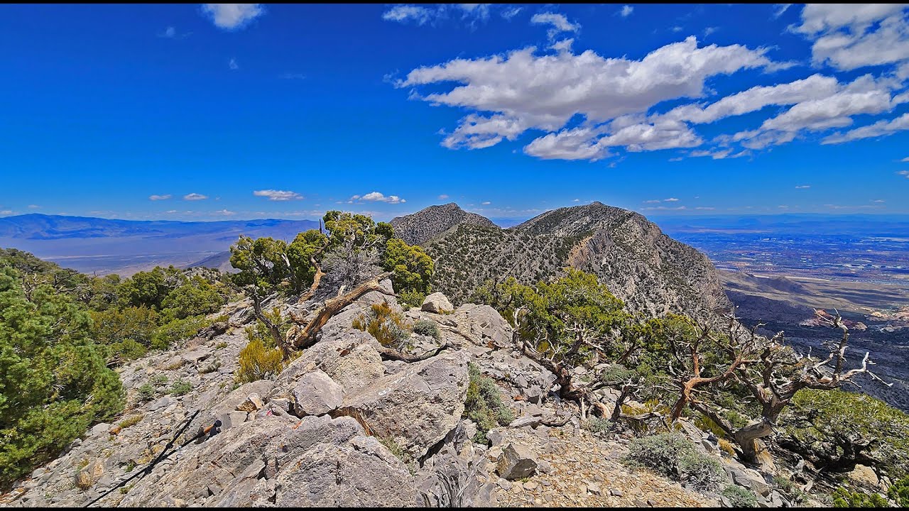
The remoteness of the La Madre Ridgeline has made it pristine wilderness above the surrounding, oven-hot, barren desert below. As you approach the summit of the ridgeline you’ll find yourself in a beautiful pinyon pine and juniper forest. You’ll feel as if you’re the first human to traverse an unknown wilderness. And as you ascend, the views all around continually expand until you may feel as if you are on top of the world!
The Adventure Route
I parked at a spacious, but unmarked parking area at about 4,500ft elevation just above the intersection of Kyle Canyon Road and Harris Springs Road. On maps, it’s called “The Twilight Zone”. There is an awesome network of mountain bike trails there.
From The Twilight Zone, I headed up Harris Springs Road on foot for about 4 miles to the unmarked intersection with the unmarked (and to my knowledge unnamed) La Madre Mountains Wilderness approach road. You can navigate the well-graded Harris Springs Road with a good 2WD vehicle. You’ll need a high-centered, preferably 4WD vehicle to navigate the La Madre approach road.
Once you turn onto the La Madre approach road, you can see the best view of El Bastardo on the La Madre Ridgeline above to the South. This is a good time to get your bearings. Notice three main approach ridgelines to El Bastardo Summit: One on the right (North), one on the left (South) and one in the middle. I ascended the approach ridgeline on the right. Also note the high point on the ridgeline to the left (East) of El Bastardo. That’s Burnt Peak. Your return trip will form a loop adventure heading from El Bastardo down a saddle on the ridgeline and then up to Burnt Peak and finally descending Burnt Peak’s approach ridgeline to the summit of the La Madre approach road.
The La Madre approach road is the last road or trail you will see for the majority of this adventure. Ascend the La Madre approach road for about 3 miles, then angle through the wilderness to the right, soon descending into a nice wide gravelly wash (see the map on the linked page for the approximate point to depart the road).
Continue up the wash for a little less than 2 miles. The wash is wide and easy to navigate, but there are a few confusing stretches, so be aware of the surrounding terrain and the general path of the wash. Once you reach the base of the El Bastardo approach ridgeline, turn left (South) out of the wash and onto the ridgeline. This is the longest approach ridgeline and therefore, the most gradual.
On the ridgeline, you’re in a beautiful pine and juniper forest with continually expansive views all around. Near El Bastardo summit there are a few low, easy limestone ledges to navigate. Arrival at the summit of the ridgeline is always surprisingly spectacular, with Red Rock Canyon directly below.
From the summit, head East toward Burnt Peak. You’ll need to navigate a few brief, light class 3 limestone sections. Stay just below the North edge of the ridgeline. Once on Burnt Peak summit, the descent following Burnt Peak’s approach ridgeline to the campground at the upper end of the La Madre approach road is fairly easy with a few light class 3 limestone sections to navigate.

Информация по комментариям в разработке