Passage 1 of the AZT is a challenge. / @flynnhikes It starts at an elevation of 5,925’ and quickly goes up to 9,000’, water can be scarce, it’s generally cold, snowy and very windy in the winter when many thru hikers start their northbound trek, and you won't have a cell signal along much of the passage. Getting to Sierra Vista, the small town nearest to the trailhead, is its own challenge because there’s no commercial airline, bus or train service to it. Lyft or Uber? Don’t hold your breath. Once you're finally near Sierra Vista, reaching the trailhead at the U.S.-Mexico border in Coronado National Memorial, 20 miles south of town, requires a drive on a miles-long dirt road and hikes on two trails before you’re at the southern terminus.
This video describes various ways of getting (1) to Sierra Vista, the town nearest to the southern terminus and (2) to the AZT’s southern terminus. And then (3) you’ll see some of the things you can expect along Passage 1, from the U.S.-Mexico border to Parker Canyon Lake.
Here's some extra info that I didn't manage to fit into this video:
1. I've spoken to many thru hikers on their first day or two of their hike. Without exception they say that passage 1 is harder than they expected. Most didn't expect it to be so steep, to be so affected by the elevation (9,000'!), to get started so late in the day and make so few miles on their first day, or to already have trouble finding water. 2025 had an exceptionally dry winter, and many water sources went dry in the spring, and Bathtub Spring went dry late in the summer.
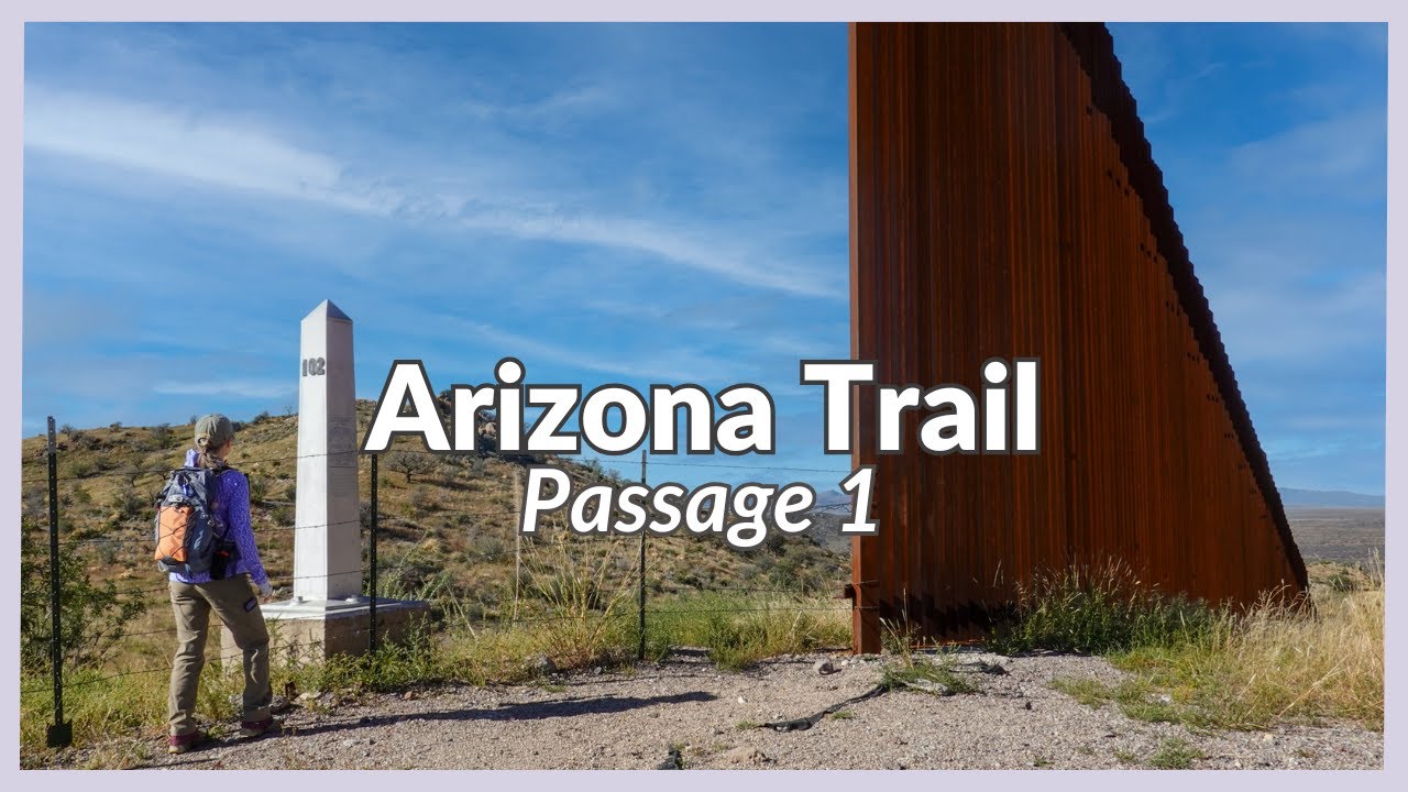
2. Border monument 102 (shown at the beginning of this video) is about 10' on the U.S. side of the U.S.-Mexico border. Concertina wire was added in October 2025 due to upcoming border wall construction. By late 2026 the lone segment of tall, steel bollard fencing that you see next to the monument will be joined on both sides with other fencing, and the monument will be behind it.
3. Most years there are rabies outbreaks in southeastern Arizona. In 2025 there was an especially high number of rabid fox and skunk attacks, with many local residents and some hikers requiring rabies shots. Even coyotes and and coatis can be rabid. If a wild animal approaches you it's not because it likes you, it's because it has rabies. That said, squirrels may be friendly because they want to eat through your pack and get to your food. Seek medical advice immediately if you think you've been near a rabid animal.
4. Regarding train service, Amtrak stops in Benson, a town 35 miles north of and even smaller than Sierra Vista. The issue is that once you get off the train at what looks like a forlorn bus stop you have to figure out how to get to Sierra Vista. Asking a trail angel, arranging for a shuttle or hitching are essentially your only options.
5. Speaking of trail angels, some do it at no cost and some ask for reimbursement of gas/mileage/time. Ask the "angel" before you finalize your ride so that both of you have the same expectation as to whether it's free or not.
6. The dirt section of the road from the visitor center to Montezuma Pass closes to vehicle traffic for maintenance for several days in mid-March. To get to the terminus from the visitor center you'll have to hike up to the Yaqui Ridge Trail junction via the longer section of Joe's Canyon Trail or arrive before 7AM at which time the road closes.
7. The AZT’s awesome website has lots of great information https://aztrail.org/ .
8. Don't go sawing logs on federal land unless you're a certified sawyer. Yes, I'm certified. 🙂🪚
9. If you want complete, accurate and interesting details about trails in the Huachucas, pick up Leonard Taylor's Trails of the Huachucas trail guide (2019) and the accompanying Trail Map of the Huachucas. You can buy them at Ramsey Canyon Preserve, the Sierra Vista Ranger District Station along Hwy 92 south of Sierra Vista, the Coronado National Memorial, the San Pedro House and the Carr House, on Amazon and at various outdoor stores. I highly recommend them!
10. Businesses in this area that I've heard good things about:
*TerraSol in Patagonia, near the end of passage 3, is a popular place to stop and regroup after some tough days on the trail. https://www.terrasolaz.com/
*Finding True North are hikers based in Tucson who also run a scheduled shuttle to the southern terminus. https://findingtruenorth.co/
0:00 Why so difficult?
1:15 Drive yourself
1:44 Arrive in Phoenix
2:33 Arrive in Tucson
3:00 The almost last leg
3:43 The last leg
5:00 Southern terminus
9:00 Bathtub Spring
How to get to the start of the Arizona Trail

Информация по комментариям в разработке