After you have performed the weight and balance for your aircraft you are now ready to start plotting your course and checkpoints. This video will show you how to plot your course and determine your checkpoints.
In the video, I will be using an example of a flight from Gillespie Field (KSEE) near San Diego, CA to Apple Valley (KAPV) just east of Los Angeles, CA.
You can do this one of two ways; using a sectional chart and a plotter tool or an application such as Foreflight on your tablet or computer. In this video, I am using Foreflight because it is much quicker and easier to show in a video. Although Foreflight is much easier, I advise all student pilots to use a sectional chart and plotter when they first start planning cross-country flights.
The first thing to do when plotting your cross-country is to draw a straight line course from your departure airport to your destination airport.
Once you have drawn the straight line course the next thing to do is follow the line looking out for any terrain, airspace, TFRs, or other obstacles that you may want to fly around or fly above. While doing this, find prominent landmarks such as lakes, highways, mountains, airports, dams, etc. that would be easy to see from the air and can be used as a checkpoint for your cross-country plan. Each checkpoint should be about 10 or 20 nm away from the next checkpoint.
Once you have set the checkpoints you are ready to determine your cruise altitude. To determine your cruise altitude, make sure you are at least 500' above the tallest nearby terrain, that you are above or below any airspaces that you wish to avoid, and that you are obeying the hemispherical rule. The hemispherical rule states that during a cruise a pilot must fly at an even thousand plus 500 feet when traveling west (between the headings of 180 to 359) and at an odd thousand plus 500 feet when traveling east (between the headings of 0 and 179).
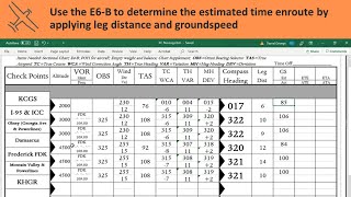
The last thing you will do is determine the true course and distance to each checkpoint. This can be done easily on Foreflight (although Foreflight will automatically convert true course to magnetic course) and can be done on your sectional chart using your plotter tool. To find your true course, line up the plotter with the leg of your flight you wish to find the true course for. Once you are aligned with your course, spin the wheel so that 0 is pointing straight up and the vertical lines on the wheel are parallel to the vertical lines on your sectional chart. Now, with your wheel aligned with your chart and your plotter aligned with your course, you can read your true course of the wheel where the straight edge of the plotter meets the edge of the wheel.
To find your distance the only tricky thing to look out for is that there are 4 separate scales on your plotter tool. There is a scale for nautical miles on a sectional chart, nautical miles on a terminal area chart, statute miles on a sectional chart, and statute miles on a terminal area chart. Most likely you will be using nautical miles on a sectional chart so just make sure you are measuring off the right scale on your plotter tool.
◽️◽️◽️◽️◽️◽️
🛩️ To get ALL our Video Lessons plus Written Lessons, Quizzes, Audio Lessons, eBooks, Test Prep books, Flash Cards, Practice Tests & Live Lessons with myself you can join our
Online Ground School here: https://parttimepilot.com/private-pil...
🛩️ Checkride Prep: https://parttimepilot.com/private-pil...
🚀 FREE COURSE & Facebook Group:
We are trying to tackle the problem of flight training expenses head on. We do this by educating students on how to save money, how to plan financially, where to get the best training, scholarships, and more to come.
You can join our Facebook group "𝐅𝐢𝐧𝐝 𝐖𝐚𝐲𝐬 𝐭𝐨 𝐏𝐚𝐲 𝐟𝐨𝐫 𝐅𝐥𝐢𝐠𝐡𝐭 𝐓𝐫𝐚𝐢𝐧𝐢𝐧𝐠" here:
/ 668346764951657
/ parttimepilot (𝐏𝐏𝐋 𝐬𝐭𝐮𝐝𝐲 𝐠𝐫𝐨𝐮𝐩)
/ parttimepilotifr (𝐈𝐅𝐑 𝐬𝐭𝐮𝐝𝐲 𝐠𝐫𝐨𝐮𝐩)
🎁 And you can enroll in our free course "𝐇𝐨𝐰 𝐭𝐨 𝐁𝐞𝐜𝐨𝐦𝐞 𝐚 𝐏𝐢𝐥𝐨𝐭 & 𝐒𝐚𝐯𝐞 𝐌𝐨𝐧𝐞𝐲" here:
https://parttimepilot.com/free-how-to...
🔥Already a Student Pilot? Get our 200+ page 𝐅𝐑𝐄𝐄 𝐬𝐭𝐮𝐝𝐲 𝐠𝐮𝐢𝐝𝐞 to study for the FAA Written on any device, wherever you go here... completely FREE:
https://parttimepilot.com/free-study-...
💵 Recommended Products & Discounts: https://parttimepilot.com/recommended...
◽️◽️◽️◽️◽️◽️
🛫 Timestamps:
00:00 Intro
00:14 How to Plot and Measure Cross-Country Flight Courses
00:37 Step 1: Departure airport to Destination airport
01:19 Step 2: Checkpoints
10:20 Step 3: Cruise Altitude
13:20 Step 4: True Course and Distances to each checkpoint
13:57 No Foreflight?... Chart & Plotter
◽️◽️◽️◽️◽️◽️
🛫 WHERE TO FIND US:
🌐 https://parttimepilot.com/
/ part.time.pilot
/ part.time.pilot1
/ part.time.pilot


Информация по комментариям в разработке