In this video I will be doing a drone flight over historic fort henry & Old Harrys rocks Info below,
/ @tonyandteddysworld
https://www.buymeacoffee.com/tonyk5537
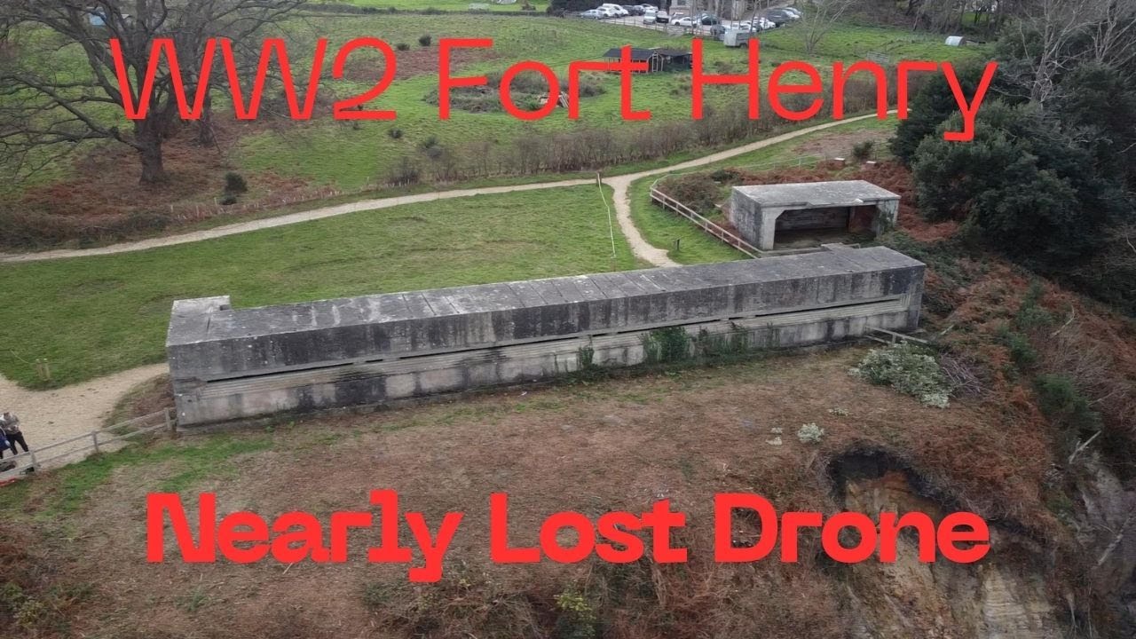
Fort Henry is a Grade II listed[1] World War Two observation bunker overlooking Studland Bay, in Dorset. It was built in 1943 to defend the bay from possible German invasion along with other beach defences such as gun emplacements, Type 25 pill boxes and concrete Dragon’s Teeth anti-tank obstacles (which have also been listed for protection).
Located at the top of Redend Point, on a small sandstone promontory, the bunker is 90 feet (27 m) long with walls, floor and ceiling all 3 feet (0.91 m) thick. There is an 80 feet (24 m) wide recessed observation slit. Its name derives from the home base in Ontario of the Canadian Royal Engineers who built it.
Today, it is owned by the National Trust and forms part of the Studland Beach Second World War walk.
An English Heritage spokesman commented following the bunker's listing on 20 November 2012:
Fort Henry provides an impression of the scale and significance of the preparations for D-Day and is associated with the most prominent figures of the Allied forces. Studland Bay is known for its beaches and wildlife but it is great that its role in the Second World War has now been recognised.
D-Day preparations
On 18 April 1944, six weeks before D-Day (6 June 1944), Winston Churchill, the British prime minister, was joined by King George VI, Supreme Allied commander Dwight D. Eisenhower, Field Marshal Bernard Montgomery and Acting Admiral Louis Mountbatten at the observation point to witness the largest live ammunition practice of the entire war.
Operation Smash
On 4 April 1944, Operation Smash was held at Studland Bay with the Duplex Drive Valentine tanks. A trial run of the tanks ran into difficulty when a change in the weather adversely affected the sea conditions. Six stricken tanks sank with the loss of six crew members.[6] The lesson learned from this trial was the tanks would not survive being launched too far from the beach and consequently on D-Day itself the tanks were released in shallow water.
The remains of the tanks were protected as a scheduled monument in 2019
Old Harry Rocks
are three chalk formations, including a stack and a stump, located at Handfast Point, on the Isle of Purbeck in Dorset, southern England. They mark the most eastern point of the Jurassic Coast, a UNESCO World Heritage Site.
Location
Old Harry Rocks lie directly east of Studland, about 2.5 miles (4 km) north east of Swanage, and about 5 miles (8 km) south of the large towns of Poole and Bournemouth. To the south are the chalk cliffs of Ballard Down, much of which is owned by the National Trust. The rocks can be viewed from the Dorset section of the South West Coast Path.
Van Life UK
Formation
The chalk of Old Harry Rocks used to be part of a long stretch of chalk between Purbeck and the Isle of Wight, but remained as a headland after large parts of this seam were eroded away. As the headland suffered hydraulic action (a process in which air and water are forced into small cracks by the force of the sea, resulting in enlarging cracks), first caves, then arches formed. The tops of the arches collapsed after being weakened by rainfall and wind, leaving disconnected stacks. One of these stacks is known as Old Harry. Old Harry's Wife was another stack which was eroded through corrosion and abrasion, until the bottom was so weak the top fell away, leaving a stump. Hydraulic action is the main cause of erosion (shear force of the waves) that damaged the rock and caused it to fall away.
Geology
Old Harry is formed by erosion processes, which will eventually remove the stack, whilst new stacks develop. Some people desire to preserve the rocks and protect them from the erosive processes that formed Old Harry. The National Trust, who own the stacks in perpetuity, have experience in looking after the coast, and have found that "working with natural processes is the most sustainable approach".
Legend
There are various stories about the naming of the rocks. One legend says that the Devil (traditionally known euphemistically as "Old Harry") slept on the rocks. Another local legend says that the rocks were named after Harry Paye, the infamous Poole pirate, whose ship hid behind the rocks awaiting passing merchantmen.[3] Yet another tale has it that a ninth-century Viking raid was thwarted by a storm and that one of the drowned, Earl Harold, was turned into a pillar of chalk

Информация по комментариям в разработке