The July 2022 Savage River Whitewater Release...in the Heart of Western Maryland & Mountain Maryland's Appalachian Region: Shredding the Savage River at 1,000cfs, at the South Savage Mountain Natural Area of the Savage River State Forest, from Swanton, MD to the Confluence of the North Branch of the Potomac River in Bloomington, MD.
This release was the second of the three annually scheduled whitewater releases for the Savage River. The yearly schedule for the releases are comprised of the: first Saturday of June, first Sunday of July, & the fourth Saturday of September, with the ramp up, window of peak flow, and ramp down, lasting from 7:00 AM to 5:00 PM. As with the five scheduled releases of the Jennings Randolph Lake/Reservoir for the North Branch of the Potomac River, each release is dependent on sufficient hydrologic & reservoir conditions, sometimes resulting in the August/September releases being cancelled due to impacts from low lake levels from insufficient rainfall & significant use of water quality storage within the reservoirs. Ordinarily, the June & July releases can be counted on, in part with the four spring releases for the North Branch of the Potomac River/Barnum Whitewater Area.
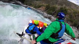
This was my second shredding experience; it was just as much of a thrill & livelier than my debut shredding trip from the June release. This trip reached a peak flow of 1,030cfs, making for 51 more cfs than the June release trip. From the view of Savage River Road, the flow appeared to look noticeably higher than 1,000cfs, enough so that at the end of the day several longtime kayakers remarked that "it felt juicier than normal," agreeing that the flow equated to an extra 200cfs, particularly from what was described as "a six foot tall standing wave" at the class IV line of Triple Drop, which was the only drop & line experience that truly felt class IV, feeling more punchier & grabby than the June release. There was a significant downpour the night before. No active runoff was noticed below the gauge, & although there are no tributaries below the Put-In, several attested the flow was indeed darker, & pushier. The peak recorded flow was 1,030cfs. The ramp up began at 8:30 AM, reaching 1,000cfs at 11:15 AM, & holding to 4:00 PM, which ramped down until 7:45 PM. The minimum runnable level began at 9:15 AM (722cfs) & dropped below the minimum runnable level at 5:45 PM (219cfs). As with the June release, there was another shredder wrapped around the center pillar of the first bridge just below the Put-In, which again appeared to be a STAR Slice. Viewable from the road near Hutch's Demise was an abandoned large yellow commercial raft that was lodged up on its side into a tree & rock outcropping.
"Jesus said "Whoever believes in me, as Scripture has said, rivers of living water will flow from within them."" - John 7:38
Date: July 3, 2022
Trip Length: 4.40 Miles
Class: III (IV)
Elevation/Avg Gradient:
Put-In: 1,337ft.
Take Out: 961ft.
Avg Gradient: 85 feet/mile (1.4%), with sections being 100 feet/mile (1.9%)
Level (flow rate): 3.36ft./1,030cfs
Water Temperature: 53°F
Stream Gauge: USGS 01597500 SAVAGE RIV BL SAVAGE RIV DAM NEAR BLOOMINGTON, MD
Location: the section of the Savage River from below the Savage River Reservoir/Dam, along Savage River Rd to the confluence of the North Branch of the Potomac River at Bloomington, MD
Garrett County Maryland: Swanton, MD to Bloomington, MD
Savage River State Forest: South Savage Mountain Natural Area
Put-In:
The short footpath just upstream from the concrete Savage River Road Bridge (39°30'10.4"N 79°07'33.4"W)
See American Whitewater reporting for information on the primary & official upstream Put-In locations for the three annual whitewater releases
Take Out:
Beryl Bridge, on West Virginia Route 46/Beryl Road, at the Confluence of the North Branch of the Potomac River in Bloomington, MD (39°28'47.7"N 79°03'58.3"W)
the spacious Upper Savage Woodyard gravel parking area off of MD 135 just before the bridge (39°28'53.1"N 79°04'04.9"W)
Alternate Take Out:
the MD 135 Bridge, at the Confluence of the North Branch of the Potomac River in Bloomington, MD (39°28'50.5"N 79°04'04.9"W)
Per American Whitewater: “Paddle under the bridge & take a right to paddle upstream on the North Branch Potomac for 50 yards or so. Take out just downstream of the old bridge, & carry your boat across the main road bridge over the Savage to reach the parking area.”
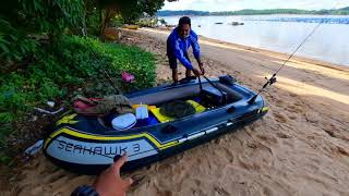
Featured Shredder: STAR Slice Cataraft
Featured Scenes:
Mapping (0:11)
Put-In to Piedmont Dam (1:05)
Piedmont Dam & Garrett Bridge/First Suspension Footbridge AKA Swinging Bridge Dam (4:55)
Observation Deck & Second Suspension Footbridge (6:35)
Crisscross/Double Hydraulic (7:55)
Triple Drop & Memorial Rock (9:17)
Savage River Outfitters (10:01)
Hutch’s Demise (10:55)
Savage River Road Bridge (14:44)
First Island (15:55)
Kayakers, Shredders, & Rafters at the Savage River Road Bridge (17:08)
Hydrograph/Maps (18:47)


Информация по комментариям в разработке