Get your Nitto Tires HERE! - https://bit.ly/3GGpD6Z
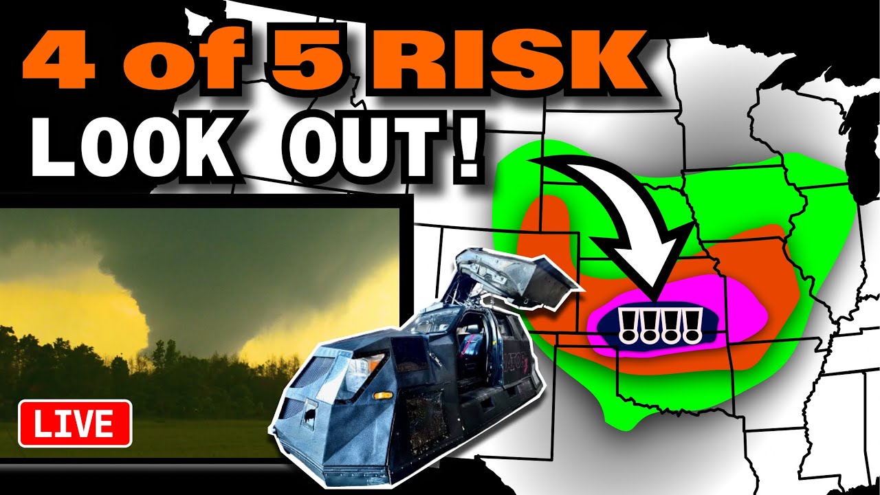
🌪️ SEVERE WEATHER OUTLOOK – TUESDAY, JUNE 17, 2025 (16:30Z Update)
SPC Risk Level: MODERATE (Level 4 of 5)
Valid through 7 AM CDT Wednesday
📍 Major Cities in Risk Zones
🔴 MODERATE Risk: Tulsa, OK · Wichita, KS · Enid, OK · Stillwater, OK · Hutchinson, KS
🟠 ENHANCED Risk: Broken Arrow, OK · Joplin, MO · Salina, KS · Emporia, KS · Dodge City, KS
🟡 SLIGHT Risk: Denver, CO · Oklahoma City, OK · Kansas City, MO · Colorado Springs, CO · Aurora, CO
🟢 MARGINAL Risk: Baltimore, MD · Milwaukee, WI · Washington, DC · Nashville, TN · Atlanta, GA
🌪️ Tornado Risk Zones
🟤 5% Tornado Risk: Tulsa, OK · Wichita, KS · Broken Arrow, OK · Joplin, MO · Enid, OK
🟢 2% Tornado Risk: Washington, DC · Oklahoma City, OK · Kansas City, MO · Colorado Springs, CO · Aurora, CO
What the Percentages Mean
A 5% tornado risk means there's a 1 in 20 chance of a tornado within 25 miles of a point. This indicates a higher-end threat for tornadoes, especially across northern Oklahoma into southeastern Kansas where supercells are expected.
📝 Overview
An intense severe weather outbreak is likely this afternoon and evening across the southern Kansas and northern Oklahoma corridor. After overnight convection pushed an outflow boundary southward, rapid destabilization under strong heating is leading to extreme instability in this zone. Forecast soundings show strong low-level shear and lapse rates supportive of tornadic supercells, very large hail, and a bowing MCS producing widespread damaging winds.
⛈️ Hazards Include
🧊 Very large hail (2–3+ inches possible in KS/OK supercells)
💨 Widespread damaging wind gusts (70–100 mph potential)
🌪️ Several tornadoes possible — including a few strong
🕓 Timeline
🕒 3–6 PM CDT: Supercells develop rapidly from south-central KS into northern OK
🌆 6–9 PM CDT: Storms congeal into one or more MCSs with widespread damaging wind threat
🌙 9 PM – 2 AM CDT: Wind/hail threat continues southeastward into northeast OK and possibly northwest AR
📌 Regional Notes
🔴 South-central KS into northern OK: Prime zone for violent wind gusts and large hail — tornadoes possible early
🟠 North-central OK to northeast OK: Wind risk continues with congealing MCS
🟡 Eastern CO/Southeast WY: Supercells expected in foothills with very large hail and possibly a tornado
⚠️ Stay Weather-Aware
If you are in or near Tulsa, Wichita, Stillwater, or Enid, have multiple ways to receive warnings and identify your shelter plan. These storms will evolve quickly and could produce destructive wind and large hail with little warning.
———————————
In-Vehicle
Driver, Man-of-Action - @ReedTimmerWx
Navigator, Man-of-Music - @localmanweatherofficial
Engineer, Man-of-Iron - @willclay25
Studio
Guy in the corner - @brianvotoole
And HUGE Thanks to RED EARTH TECH! - https://www.red-earth.tech/


Информация по комментариям в разработке