The technologies used for planning, design and construction have been developing considerably over the past decade. Since today's objects are very complex, it is necessary to provide a faster and more accurate way of recording the existing condition. GO2BIM uses the modern 3D laser scanning method to provide fast and high-quality collection and processing of a large amount of spatial data.
Laser scanning of biggest Thermal Power Plant in Croatia is an example of the high-quality application of this technology for the purpose of creating the project documentation of the existing condition. While working in the field, a modern Faro laser scanner was used for detailed scanning of Thermal Power Plant, with approximately 2500 scans recorded. Along with the data collected using the laser scanning method, 3600 photographs were recored with the application of photogrammetry, using a drone.
The laser scanner is of practical size and, together with an adjustable tripod, it is easy to move the scanner even on a complex object with many narrow passages and obstacles such as a thermal power plant. It is precisely because of its ability to use it in hard-to-reach and complex parts of a facility, the use of a laser scanner enables immeasurable speed and accuracy of spatial data collection in comparison to conventional manual measurements.
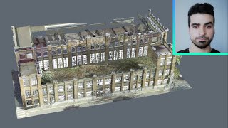
After completing the field work, collected data is processed in the office. Scans are processed and registered to obtain a whole and unique point cloud of the scanned area. The point cloud is then georeferenced, i.e., placed in the reference coordinate system of the Republic of Croatia - HTRS96/TM. A georeferenced point cloud is further used to create the final detailed 3D model that faithfully displays the existing condition of the Thermal Power Plant. The aerial images recorded with the drone are also processed to obtain a whole point cloud, placed in the HTRS96/TM system, which is used to make, i.e., display topography of the recorded area.
The final 3D model is a BIM (Building Information Modeling) model that contains a number of additional information such as type and quantity of built-in building material, details on embedded equipment, various system sets etc., and it also provides architecture, engineering and construction designers with insight and tools for more efficient planning, designing and building along with infrastructure and building management. It is important to emphasize the large amount of complex metal structures of the thermal power plant, which, thanks to the experience of our employees, is displayed faithfully and in detail in the BIM model. The level of detail used for Thermal Power Plant BIM model was LOD 300. In this way a high-quality model of high precision, size, shape, location and orientation was created.
3D laser scanning enables quick and efficient collection of accurate spatial data of large complex objects. By processing the collected data, a whole point cloud is placed in the official reference coordinate system and used to create a final BIM model that faithfully displays the existing condition. The application of the laser scanning method enables a faster, simpler, high-quality and more economical way of measuring, and the production of project documentation in comparison to traditional methods.


Информация по комментариям в разработке