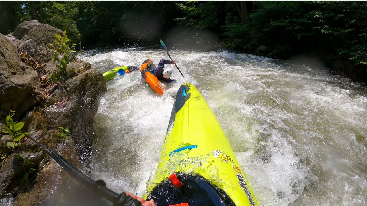
The June 2023 Savage River Whitewater Release, at 1,020cfs: Combat Roll at Triple Drop's Memorial Rock...One for the Textbooks
Mike Z. @mikelzinn1085 confidently executing and setting the example for a model high stakes combat roll at Memorial Rock of Triple Drop (the third drop of the Triple Drop rapid series). While under the waves for the vast extent from Memorial Rock to the end of the action - which is a considerably long time to hold it by Savage standards - Mike sets a champion example of how to boldly keep cool and calm in the chaos, showing how to time it for how long to hold it for the right time and placement to make the move. Alongside him at the moment of impact, Bill B., skillfully reactively demonstrates an awesome brace, in simultaneously putting on the brakes to prevent colliding into Mike and keeping himself just enough on edge from going over.
Details:
Date: June 3, 2023
Trip Length: 4.4 Miles
Triple Drop/Memorial Rock: 1.40 miles from the Put-In
Class: III (IV)
Elevation/Avg. Gradient:
Triple Drop, at Memorial Rock: 1,162ft.
Put-In: 1,337ft.
Take Out: 961ft..
Avg. Gradient: 85 feet/mile
"The average gradient for the Savage River's whitewater section is 75 feet/mile (1.4%), with sections at 100 feet/mile (1.9%)"*
Level (flow rate): 3.34ft./1,020cfs
Water Temperature: 50°F
Stream Gauge: USGS 01597500 SAVAGE RIV BL SAVAGE RIV DAM NEAR BLOOMINGTON, MD
Location: Triple Drop - Memorial Rock, the third and final drop of the Triple Drop series
39°29'48.1"N 79°06'18.0"W (39.496685, -79.105008)
Garrett County Maryland: Swanton, MD to Bloomington, MD
Savage River State Forest: South Savage Mountain Natural Area
Appalachian Plateau Province
Appalachian Mountain Range
Allegheny Mountains
Allegheny Front
Big Savage Mountain
Featured Kayaks:
Pyranha 12R
Pyranha Ripper 2 @mikelzinn1085
Pyranha Scorch @hipernet
Grove, Ed; et al. (1994). Appalachian Whitewater, Volume II: The Central Mountains. Menasha Ridge Press, Birmingham, Alabama. pp. 134–7.
Educational Resources:
American Whitewater: "Savage Dam to North Branch Potomac River (Site of 1989 World Championships)" - https://www.americanwhitewater.org/co...
USGS Stream Gauge: USGS 01597500 SAVAGE RIV BL SAVAGE RIV DAM NEAR BLOOMINGTON, MD:
https://waterdata.usgs.gov/monitoring...
https://waterdata.usgs.gov/nwis/uv?si...
US Army Corps of Engineers North Branch Potomac River and Savage River Release Schedule (Current & Projected) - https://www.nab-wc.usace.army.mil/nab...
River Facts: https://www.riverfacts.com/rivers/115...
Wikipedia:
Savage River: https://en.wikipedia.org/wiki/Savage_...)
Savage River State Forest: https://en.wikipedia.org/wiki/Savage_...
Maryland Department of Natural Resources: Savage River State Forest - https://dnr.maryland.gov/forests/Page...
Kenny, Hamill (1945). West Virginia Place Names: Their Origin and Meaning, Including the Nomenclature of the Streams and Mountains. Piedmont, WV: The Place Name Press. p. 555.
Grove, Ed; et al. (1994). Appalachian Whitewater, Volume II: The Central Mountains. Menasha Ridge Press, Birmingham, Alabama. pp. 134–7.
"God Is Our Refuge And Strength, an Ever-Present Help In Trouble. Therefore We Will Not Fear, Though The Earth Give Way And The Mountains Fall Into The Heart Of The Sea, Though Its Waters Roar And Foam And The Mountains Quake With Their Surging. There Is A River Whose Streams Make Glad The City Of God, The Holy Place Where The Most High Dwells." - Psalm 46:1-4

Информация по комментариям в разработке