https://axera.org/to53/
Ukiyoe of the Fifty-three Stages of the Tokaido drawn by Hiroshige Utagawa, I researched the view from where it was seen and actually went there. The route to the places depicted together with explanations of the history and topography of the area are also included in the book.
Click here to view the 100 Famous Places Edo.
Japanese version
https://www.axera.co.jp/edo100/index....
English version
https://www.axera.co.jp/edo100views/i...
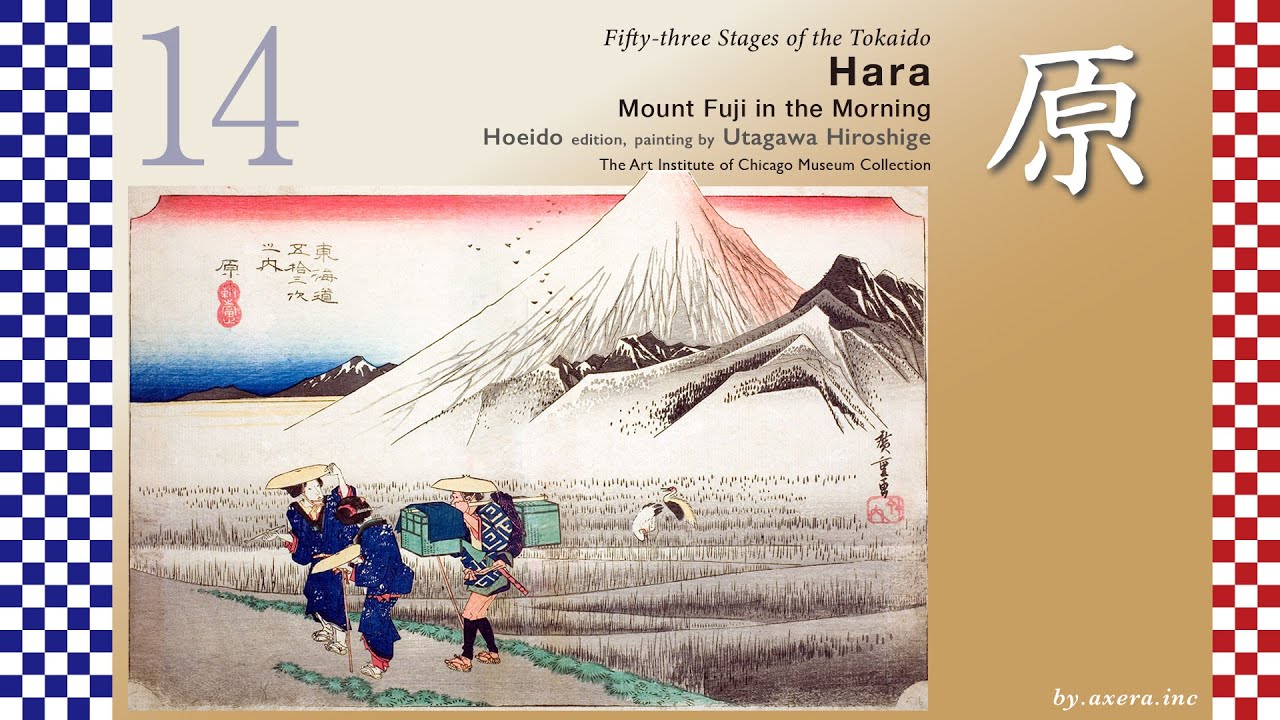
ifty-three Stages of the Tokaido
Hara
Mount Fuji in the Morning
Hoeido edition, painting by Utagawa Hiroshige
The Art Institute of Chicago Museum Collection
This painting depicts a traveler looking back at Mt. Fuji just after sunrise, just past Hara-juku.
Hara-juku is about 6 km from Numazu-juku, and is a very small relay station with one Honjin and one Waki-honjin.
The Tokaido road splits off from the old No. 1 Senbon Kaido road at Kongoji Temple, and beyond that point, around Nishimakado, is the western end of Numazu-juku.
Then, before Katahama Station, cross Matsunaga Ichirizuka and continue straight ahead in a northwesterly direction.
JR Tokaido Line crosses the tracks, and you will soon reach Higashi-mitsuke, the eastern end of Hara-juku.
There are two things in Suruga: Mt. Fuji and Hakuin of Hara.” This is a popular song in praise of Hakuin, a Zen monk of the mid-Edo period who is said to be the founder of the Rinzai school of Zen Buddhism. Shoinji Temple, where Hakuin's tomb is located, is just ahead on the left.
About 1.4 km from that Higashi-mitsuke, a short distance from the entrance to JR Hara Station, is Nishi-mitsuke, which shows how small Hara-juku is. To the left of Nishi-mitsuke is also a sake brewery founded in the Edo period that produces a local sake named Hakuin Masamune.
Further ahead is Hara-juku's Ichirizuka, and further ahead, around the Tennosha Shrine and Sengen Shrine, is the area where Hiroshige painted “Mount Fuji in the Morning”.
At that time, this area was called Ipponmatsu-shinden, and there was a vast swamp called Ukishima-numa on the north side. The area surrounding the waterfront was also quite extensive, and it was a marshy area with no boundaries. The map includes the Ukishima-numa, which no longer exists.
Here is a map from the Geospatial Information Authority of Japan showing the current elevation differences.
During the Edo period, the light blue areas on this map were almost entirely marshlands and swamps.
In the very early days, a part of Suruga Bay gradually became a vast marshland as sand and gravel from the Kano River, Fuji River, and Mount Aitaka alluviated and formed a sandbar, which eventually became a lagoon.

Информация по комментариям в разработке