Harris Mountain Triangle Complete | Mt. Charleston Wilderness, Nevada | Visit https://lasvegasareatrails.com/harris... | Navigate the entire Harris Mountain Triangle. The route begins at the Fletcher Canyon Trailhead parking area, takes the Acastus Trail East, connects with the Escarpment Trail looping above the Escarpment from West to East, ascends the long Harris Mountain Eastern Approach Ridge to Harris Mountain summit, descends Harris Mountain summit on the Western Approach Ridge, connects with Rainbow Ridge Rd along the base of the ridge at the Rainbow Subdivision, takes a right onto Forest Rd 579 to circle the lower base of the ridge, finally taking the Acastus Trail back to the starting point at the Fletcher Canyon Trailhead parking area. The entire adventure took about 12 hours.
Having traversed the Western approach ridge a number of times, documented in LasVegasAreaTrails.com ( https://lasvegasareatrails.com/fletch... ) this adventure focuses mainly on the unknown Eastern Approach Ridge.
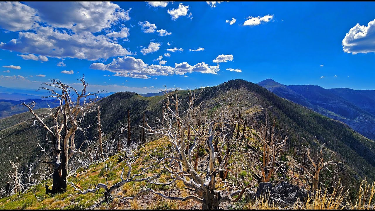
The Eastern Approach Ridge is accessed from the Escarpment Trail at the upper Eastern edge of that loop, marked by a bench. The Eastern Approach Ridge with its multiple high points is much more complex and time-consuming than the Western Approach Ridge. However, the views up and down Kyle Canyon and surrounding high points offer a unique perspective of the wilderness. And there are unique video clips of this long, complex, rarely traversed ridge.
From the bench at the base of the ridge ascend two huge initial rounded hills for an elevation gain of around 1,000ft. Then, navigate below a series of cliffs to an ascent point toward the upper center of the ridge. I call the stretch navigating the steep slope below the cliffs “The Terrible Traverse”. Just beyond the cliffs I headed straight up an incredibly steep, loose rock slope to attain the upper center of the ridge. Hindsight says it may have saved 2-3 hours to continue to traverse two ridges over, then ascended that second, much more gradual and forgiving ridge to the Harris Mountain summit area. However, the route I took got me to the center of the ridge at a lower point enabling a longer stretch on the upper ridge.
Once on the upper center of the ridge the angle of ascent became much more gradual. Navigating the wide center of the ridge presented the most spectacular views in all directions. It was like being on the mountaintop the entire way! And after the harrowing scramble up the loose rock cliff, the ridgetop was mostly a nice peaceful walk.
There were a series of four high points to navigate along the ridgetop on the way to Harris Mt. summit. Two had some mild rocky cliff areas to negotiate. One highest summit before Harris Mt. Summit, was about the same elevation as Harris Mt. itself and had its own summit marker.
With only two hours daylight remaining, I began to descend the Western Approach Ridge from Harris Mt. Summit. The most complicated sections on that ridge are just below the summit. Both are burn area slopes covered with scattered, fallen trees. The highest slope is covered with a new Aspen forest, trees about 4 feet high. The lower slope is covered with grass. The Aspens and the grass conceal hidden drop-offs. Navigating fallen trees and the hidden drop-offs requires slow, careful attention.
Below these two slopes there is a ponderosa pine forest stretch, then another burn area populated mostly with the skeletons of pine and mountain mahogany. Even so, that stretch is easier than the Aspen and grass slopes above.
Finally, just before the sharp rocky lower edge of the Western ridge, it’s time to angle left and descend to Rainbow Ridge Rd. at the base of the ridge. I shoot for a yellow warning diamond, “Dip” on Rainbow Ridge Rd. The descent slope is steep, with loose rock, thick burned mountain mahogany and pine groves and fallen logs to navigate. This is where the sun went down, and it became pitch dark with no moonlight! Still, aided by four previous adventures on that ridge, the descent was relatively easy.
The unpaved Rainbow Ridge Rd. is relatively easy to follow in the dark. Forest Rd. 579 has some stretches that look more like a trail through tall grass than a road. Still relatively easy. My only light today was the light on my mobile phone yet that did to job!
Like the Eastern Approach Ridge, the Western Ridge is wild, beautiful and relatively untouched. In fact, I saw no signs of human passage on either the Eastern or Western ridges. If you traverse these wild ridges tread lightly. They are open enough that you can always weave around plants growing on the ridges. When crossing fallen logs, be careful to ensure that both ends of the log are securely anchored before putting your full weight on the log. In fact, when navigating burn areas, it’s wise not to put your full weight on any single object.

Информация по комментариям в разработке