August 2025 Monthly Weather Summary
---------------------------------
For a written August 2025 weather summary, please visit our website at https://www.weather.gov/media/gjt/Aug...
---------------------------------
August started hot and dry, with daily Red Flag Warnings in effect for much of those first two weeks. Enough moisture was present in the first few days of the month that a few high elevation thunderstorms were able to form. From these dry thunderstorms, several new fires started in the first week of the month, including the Lee Fire, which ultimately grew to over 137,000 acres. Temperatures during this period also ran consistently 5-10 degrees above normal. Moisture began to sneak back in starting on the 14th, spawning dry thunderstorms across the higher terrain each afternoon, resulting in concerns for gusty outflows and frequent lightning. The peak heat of the month arrived in the third week, with several new record highs being set at the Grand Junction Regional Airport, and elsewhere across the region. But by the end of that week, a significant push of monsoonal moisture moved into the Four Corners region. This moisture gradually overspread the region between the 23rd and the 28th. To start, showers and thunderstorms were mostly dry and produced gusty winds and lightning, but by the 24th and the 25th, the atmosphere became saturated to the surface, and the heavy rain threat began. Widespread moderate to heavy rain fell across much of the area, with heavy rainfall associated with convection in certain locations. Some of these heavier storms moved over the recent burn scars from earlier this summer, including the Lee Fire. Multiple debris flows were reported over multiple days of monsoonal moisture on the Lee Fire, including one that trapped an 18-wheeler. Things dried out by the 30th, ending things on a sunny note.
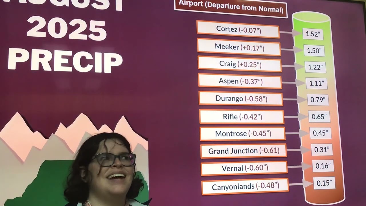
The month of August was generally warmer than normal, with eight of the ten automated weather observation stations located at airports across eastern Utah and western Colorado finishing the month with above normal mean temperatures. Mean temperature departures ranged from 0.7F below normal to 3.1F above normal. The warmest temperature recorded at any of the ten observation sites was 104F, which occurred at Canyonlands Airport, near Moab, UT, on the 21st. The coldest temperature recorded at any of the ten sites was 35F, which occurred at Craig-Moffat County Airport on the 10th. The month was also generally drier than normal, with eight of the ten automated weather observation stations finishing the month with below normal precipitation. Total precipitation departures ranged from 0.61 inches below normal to 0.25 inches above normal. The most precipitation fell at Cortez-Montezuma County Airport, where the month end total of 1.52 inches was 0.07 inches below normal. The least precipitation fell at Canyonlands Airport, near Moab, UT, where the month end total of 0.15 inches was 0.48 inches below normal.
---------------------------------
Please note that all data mentioned is collected from our automated observing stations from 10 different airports across eastern Utah and western Colorado. Some of our cooperative observers in more remote areas may have measured warmer or colder temperatures, or more or less precipitation than what was mentioned in this summary.
---------------------------------
National Weather Service
Weather Forecast Office
Grand Junction, CO

Информация по комментариям в разработке