On August 22, 2004, a cold front—the same front which eventually spawned Tropical Storm Hermine—moved off the coast of the Carolinas and drifted southward before stalling on August 24. On August 25, Surface observations indicated that a broad low pressure area developed along the deteriorating frontal boundary. Convection remained sporadic and disorganized, until thunderstorm activity began to increase and the system developed banding structure on August 26. At 1200 UTC on August 27, the low organized, and was designated as Tropical Depression Seven while located about 130 mi (210 km) east-southeast of Charleston, South Carolina.
Because steering currents were initially weak, the depression was nearly stationary in movement, although forecasts predicted a ridge to the northeast of the system would gradually steer it to the west. The cyclone was situated over warm ocean waters and contained good anticyclonic flow, leading forecast models to predict at least moderate intensification. Later that same day, it gradually drifted southwest and convective banding continued to increase. At 1100 UTC on August 28, the depression was upgraded to Tropical Storm Gaston. An Air Force Reserve Hurricane Hunters aircraft completed a flight into Gaston, revealing that the intensity was higher than previously reported. At the time, it was believed that Gaston had reached peak intensity of 70 mph (110 km/h), placing it very close to hurricane status. However, during post-season analysis, it was discovered that Gaston had briefly attained Category 1 Hurricane intensity at 1800 UTC on August 28.
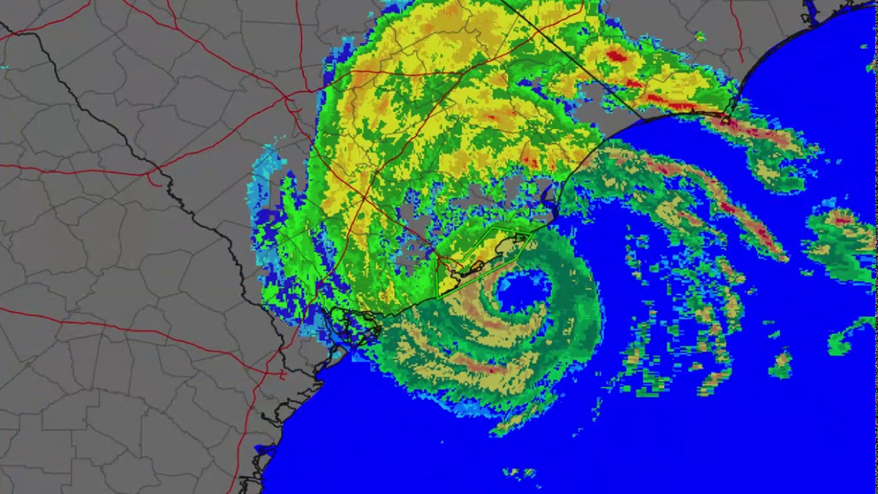
At 1400 UTC on August 29, Gaston made landfall at Awendaw, South Carolina, between Charleston and McClellanville, as a Category 1 hurricane with maximum sustained winds of 75 mph (121 km/h). The storm quickly weakened to a tropical storm as it continued northward through South Carolina, North Carolina and Virginia, and it began to gradually move north-northeastward. At 0000 UTC on August 30, the storm weakened to a tropical depression over northeastern South Carolina. As it accelerated to the northeast, it emerged in the open waters of the Chesapeake Bay and regained tropical storm status late on August 30. Initially, the system maintained a good radar signature, although satellite imagery soon indicated that convection became limited in intensity and coverage. Also, a front-like band appeared to be forming southeast of the center, which indicated signs of weakening. At 0600 UTC on August 31, Gaston crossed the Delmarva Peninsula for the waters of the Atlantic Ocean. The system began to lose tropical characteristics as it became associated with the frontal system, although there was still some thunderstorm activity wrapped around the center. Forward speed increased to about 30 mph (48 km/h), and over 60 °F (16 °C) water the storm lost all of its tropical characteristics early on September 1, and became an extratropical cyclone south of the Canadian Maritimes. The extratropical remnants of Gaston were absorbed by a larger extratropical system on September 3, about 750 mi (1,210 km) south-southeast of Reykjavík, Iceland. -Wikipedia

Информация по комментариям в разработке