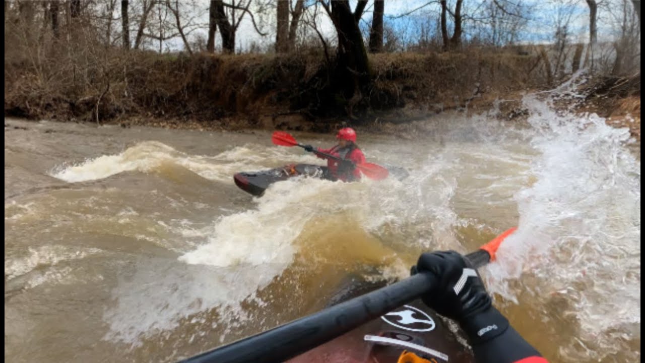
Kayaking Catoctin Creek, at 2.7ft./296cfs, in the Scenic Middletown Valley of the Blue Ridge Mountains (which are part of the Appalachian Mountains range)
Date: January 2, 2021
Trip Length: 10.94 Miles
Class: I-II
Average Gradient:
10.96 fpm for this section
12 fpm for the entire creek
Level (flow rate):
Put-In: 2.73ft./296cfs
Take Out: 2.69ft./278cfs
Elevation:
Put-In: 360ft.
Take Out: 240ft.
Stream Gauge:
USGS 01637500 CATOCTIN CREEK NEAR MIDDLETOWN, MD
Location: Jefferson, Maryland
The Middletown Valley (historically known as Catoctin Valley)
Put-In: Sumantown Rd/Catoctin Creek Park & Nature Center
Take Out: Potomac River - Lander Boat Ramp/Lock 29
Description:
Catoctin Creek is a place of special appeal and allure and could be considered "The Potomac" of the Middletown Valley, which formally and historically was once called the Catoctin Valley. The valley extends to and is separated by the Potomac River, from where its name then becomes Loudoun Valley. Both Catoctin Creek and the Middletown Valley are rich in history and cultural heritage. During the post Native Americans era, the region became inhabited by English and German settlers in the 1730s, as explorations and settlements gradually advanced further and further into the upstream reaches of the Potomac River, well before the area's scarring Civil War involvement, which had a direct and fiery impact on Catoctin Creek on September 14, 1862. The Valley is completely encompassed within the relatively narrowed strip of the Blue Ridge Province, which is one of Maryland's five physiographic provinces. Catoctin Mountain & South Mountain, the two mountains that create the valley and Catoctin Creek's drainage basin and numerous tributaries consist largely of metabasalt/basalt flows and deformed Precambrian and Cambrian metamorphic rocks, such as gneisses, granite, quartzites, schists, and slates. The Blue Ridge province includes the Blue Ridge and Appalachian Mountain ranges. The lower third of Catoctin Creek, from Jefferson to its confluence with the Potomac River can very well be thought of as "The Canyon" of the Middletown Valley, not only because of it being the lowest lying point of the valley, but because of its magnificent canyon features. Steepening cliffs and outcrops of boreal forest looking weathered metamorphic rocks because beautifully abundant, resembling the scenery of the Potomac River's North Branch, creating shear vertical rock faces close to the Potomac and in portions of Jefferson. Many of the towering outcroppings consist of Weverton quartzite and Catoctin Greenstone.
The Wild & Scenic Rivers Act - https://www.fs.usda.gov/managing-land...
In my opinion and being of abundant remarkable value, Catoctin Creek satisfies the criteria that is used to designate free flowing rivers and streams as being wild and scenic. Created by Congress in 1968, the act preserves rivers with outstanding natural, cultural, and recreational values in a free-flowing condition for the enjoyment of present and future generations (NPS).
The Put-In at the gauge/MD-17 bridge becomes overcrowded and significantly polluted during the warmer months as it becomes an overused swimming hole, just like but to a lesser extent with the posted No Trespassing "Swimmers Rock" on Poffenberger Rd. Its headwaters, Middle Creek, is the same creek as Catoctin, and changes names near Doubs Meadow Park. Catoctin is rarely runnable, which is one of its features that preserves it, preventing environmental disturbances and pollution problems, unlike the Shenandoah River at Big Eddy & Millville Trailrace, Antietam Creek, and The Needles and Potoma Wayside of the Potomac River. Catoctin massively changes in form and features at about every half a foot above 2.5ft. I am conducting research about the Huffer drowning that occurred in the 1930s at the MD 464 bridge, when attempting to transport a load of milk by wagon. I feel that Swept Away is an apt & an appropriate name for that rapid.
Featured Scenes:
Mapping & Aerial Imagery 0:10
Video - Rapid Riding & Class V Scenery 1:38
Snow & Hydrographs 15:57
Historic Bridges 16:32
Resources
American Whitewater.org:
https://www.americanwhitewater.org/co...
River Facts.com:
http://www.riverfacts.com/rivers/1147...
USGS 01637500 CATOCTIN CREEK NEAR MIDDLETOWN, MD Stream Gauge
https://waterdata.usgs.gov/md/nwis/uv...
Catoctin Creek Nature Center
https://www.recreater.com/151/Catocti...
YouTube:
Kayaking Catoctin Creek at 2.4ft. - • Kayaking Catoctin Creek at 2.4ft.
Kayaking Catoctin Creek: 2.0ft - Dagger Axis 12.0 - • Kayaking Catoctin Creek: 2.0ft - Dagger Ax...
Kayaking Catoctin Creek: 2017-2018 (Slideshow) - • Kayaking Catoctin Creek: 2017-2018 (Slides...
See my playlist titled "Rivers & Creeks: High Water" for the rare sights of Catoctin Creek at high water, ranging from 3.7ft.-5.3ft.

Информация по комментариям в разработке